Bookmark this page
:
Login
:
Subscribe
Advanced Search
Home
Subscribe
Schools
Public Libraries
Colleges & Universities
Individuals
Encyclopedias
Encyclopedia of British Columbia
Encyclopedia of Raincoast Place Names
Marine Life of the Pacific Northwest
History
Brirish Columbia in the Balance
The Curve of Time
Encyclopedia of British Columbia
Encyclopedia of Raincoast Place Names
From the West Coast to the Western Front
Go Do Some Great Thing
Indian Fishing
Lilies and Fireweed
On the Line
Tofino and Clayoquot Sound
Where Mountains Meet the Sea
Nature
Marine Life of the Pacific Northwest
Pacific Seaweeds
The Sea Among Us
Tofino and Clayoquot Sound
Views of the Salish Sea
Where Mountains Meet the Sea
Young Readers
Far West
A Field Guide to the Identification of Pebbles
Field Guides
Birds of the Pacific Northwest
Identification of Pebbles
Identification des cailloux
Insects of the Pacific Northwest
Medicinal Wild Plants of Canada
Seashells & Shellfish of the Pacific Northwest
Trees of the Pacific Northwest
Wildlife of the Rocky Mountains
First Nations
Indian Horse
Take Us to Your Chief
Indian Fishing
Novels
The Lesser Blessed
Blogs
Knowbc Blog
Marine Encyclopedia Blog
Dan Francis' Blog
Contact us
Home
Table of Contents
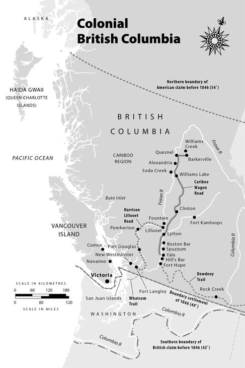
Map
Preamble: Sensing the Past
Chapter 1: Today’s British Columbia Coming into View
Chapter 2: The Year That Changed Everything (1858)
Chapter 3: James Douglas and the Colonial Office (1859–64)
Chapter 4: The Colonial Office in Action (1864–67)
Chapter 5: The Moderating Influence of Bishop Hills (1860–63)
Chapter 6: Taking Gold Miners Seriously (1858–71)
Chapter 7: Crediting Indigenous Women
Chapter 8: Along the Pathway to Canada (1866–71)
Appendix
You are here:
Encyclopedia of BC Preview
>
British Columbia in the Balance
>
Map
Map
You are here:
Encyclopedia of BC Preview
>
British Columbia in the Balance
>
Map
Back to:
Table of Contents
Next:
Preamble: Sensing the Past
Search British Columbia in the Balance