- Home
- Contents
- Maps
- Concerning Place Names
- Introduction
- Chapter 1: The Lay of the Land
- Chapter 2: The People of the Sound
- Chapter 3: The King George Men
- Chapter 4: The Boston Men
- Chapter 5: “Outrages and Disorders”
- Chapter 6: Enter the Missionaries
- Chapter 7: The Sealing Years
- Chapter 8: Setting up Shop
- Chapter 9: “Alive with Fish”
- Chapter 10: “Teeming with Riches”
- Chapter 11: The Hopeful Coast
- Chapter 12: Disconnection
- Chapter 13: Separation
- Chapter 14: Community
- Chapter 15: The Japanese
- Chapter 16: Boat Days
- Chapter 17: Wartime
- Chapter 18: Peacetime
- Chapter 19: Lovely Road
- Chapter 20: Adjustment
- Chapter 21: The War in the Woods
- Chapter 22: The Emerging Scene
- Timeline
- Acknowledgements
- Selected Sources
- About the Authors
![]()
![]()
Chapter 2: The People of the Sound
Three Nuu-chah-nulth First Nations call Clayoquot Sound their home: the Hesquiaht, Ahousaht, and Tla-o-qui-aht. Their traditional territories, or ha’houlthee, extend from Hesquiaht Peninsula in the north to Kennedy River and Long Beach in the south, and each nation recognizes a number of hereditary chiefs, or ha’wiih, within its territory. Other tribal groups inhabited the area in earlier times, each with its own territory and chiefs, among them the Otsosaht, the Kelsemaht, the Manhousaht, the Owinmitisaht, the Quatsweaht, and the Puneetlaht. Over time, these various groups either amalgamated with larger groups or were conquered by them in wars.
The traditional territory of the Hesquiaht, a name that comes from the word hiishhiisha, meaning “the sound made by eating herring eggs off eelgrass,” covers the northern reaches of Clayoquot Sound around Hesquiaht Peninsula, Hesquiaht Harbour, and Hesquiaht Lake. The Hesquiaht First Nation formed when five smaller tribes from around the harbour amalgamated, making for a combined population numbering in the thousands in the years before European contact. The traditional winter village of the Hesquiaht stands at the mouth of the harbour; home to over 200 people in the late nineteenth century, now very few people live there. Since the mid-twentieth century, Hot Springs Cove, near the entrance to Sydney Inlet, has served as the principal village of the Hesquiaht. Their five reserves comprise a total of 323.5 hectares. In total, their present-day population numbers around 700, with fewer than 100 living in Hesquiaht territory.
The Ahousaht, meaning “people living with their backs to the land and mountains on a beach along the open sea,” traditionally occupied the western side of Vargas Island, along Ahous Bay, and a small area of land across Calmus (Hecate) Passage below Catface Mountain. Through warfare and amalgamation with other groups, including the Otsosaht, Kelsemaht, and Manhousaht, their traditional territory now encompasses a large area in the heart of Clayoquot Sound covering Vargas and Flores Islands and up Herbert, Shelter, and Sydney Inlets. Early in the nineteenth century, the Ahousahts established their main village, Maaqtusiis (Marktosis), on the east side of Flores Island. Their twenty-four reserves, ranging in size from 2 to 116 hectares, make up a total of 565.6 hectares. The Ahousaht are the largest Nuu-chah-nulth tribe on the west coast, with a current population of some 2,000; approximately 800 live within Ahousaht territory.
The Tla-o-qui-aht (Clayoquot) First Nation, located in the southern end of Clayoquot Sound, took shape from an alliance of smaller groups, many originally living around Kennedy Lake. The word “Tla-o-qui-aht” translates as “people of different tribes” and also as “people of Clayoqua (Tla-o-qua),” an area of the Kennedy Lake system. Their traditional territory covers the land around Kennedy Lake and Kennedy River, as well as Tofino Inlet, Esowista Peninsula, the islands offshore, and Meares Island. Centuries ago, the Esowistaht tribe controlled the Esowista Peninsula, keeping a tight hold on ocean resources and occasionally raiding the settlements at Kennedy Lake. The Tla-o-qui-aht banded together with other smaller tribes, and together they fought back, killed all the Esowistaht, and seized their territory. “Esowista” means “clubbed to death.” Esowista village lies alongside the road north of Long Beach, adjacent to the recently constructed Ty-Histanis development. The principal Tla-o-qui-aht village is Opitsaht, located directly across the harbour from Tofino. Their twelve reserves comprise a total of 347.8 hectares, and their population now numbers around 1,000, with over 400 living in Tla-o-qui-aht territory.
These three First Nations belong to the Nuu-chah-nulth people, formerly called the Nootka. The West Coast Tribal Council adopted the name Nuu-chah-nulth, meaning “all along the mountains and sea,” in 1978. This group includes all of the First Nations along Vancouver Island’s west coast between Cape Cook on the Brooks Peninsula in the north and Jordan River in the south, extending inland about halfway across Vancouver Island, taking in Port Alberni and Gold River. The fourteen Nuu-chah-nulth First Nations in this territory share the same language and the same “aht’” suffix on their names, meaning “people of.” Their most dense areas of settlement lie in Nootka, Barkley, and Clayoquot Sounds.
Estimates vary enormously about the size of Indigenous populations in British Columbia prior to contact with Europeans. Recent estimates run to 100,000 and above, although others put the figure at just above 80,000. One undisputed point does emerge: the Pacific Northwest supported one of the most densely populated areas in North America, with at least 15,000 Nuu-chah-nulth living on the west coast of Vancouver Island prior to European contact.
The mild climate and the abundance of food made the location ideal for supporting a large population, and the Nuu-chah-nulth survived and prospered. Two extraordinary resources enabled this: the red cedar trees, which provided housing, transport, and clothing; and salmon, the Indigenous people’s main food source. Many other readily accessible seafoods also ensured their well-being.
Over countless generations, the people on the coast structured their lives in harmony with the seasonal changes of each passing year. The arrival of the herring to spawn in the inlets and bays of the west coast in late February and early March saw the beginning of the Nuu-chah-nulth seasonal cycle. The people raked and dip-netted the massive schools of spawning herring for their oil, roe, and flesh. They also gathered the herring roe when it had been deposited on kelp or eelgrass, and they submerged boughs of hemlock in areas where herring spawned to attract the roe. In his book As Far As I Know, Ahousaht elder Peter Webster recalled the excitement of herring season when he was a boy.
Revitalized from feasting on the herring, and encouraged by the warmer weather, people loaded their canoes with whatever they needed and paddled from their winter villages to their summer fishing villages and camps on the outer coast. Many of the Tla-o-qui-aht, who wintered at Opitsaht, moved round into Templar Channel to their village on Echachis Island, while the Ahousaht moved to summer settlements on various small islands and on the outer coasts of Flores and Vargas Islands.
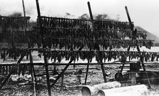
Upon arriving at their summer homes, the people began trolling for spring salmon—the first of five runs of salmon appearing each summer and fall: spring, sockeye, coho, pink (or humpback), and chum (or dog salmon). They dried or smoked their catch immediately to preserve their seasonal overabundance of fish for the lean winter months. By April, a time known as Ho’ukamil, meaning “flying flocks,” migrating ducks and geese fell to the arrows and nets of these skilled hunters. April was also the month the Nuu-chah-nulth fished for halibut and cod using a variety of methods where four men in a big canoe could catch as many as a hundred halibut in a morning’s fishing. These they dried for later consumption. Low spring tides allowed the women to gather clams, urchins, chitons, and black turban snails on the beaches, and they would continue to harvest barnacles, butter clams, and razor clams throughout the summer. In early spring they harvested the young shoots of salmonberries, thimbleberries, horsetail, and cow parsnips, and the roots of eelgrass and other plants that could be dried and stored away for winter. As the season progressed, they picked many types of berries: salmonberries, huckleberries, and salal, to name a few. These would be cooked to a paste-like consistency, formed into small cakes, placed on skunk cabbage leaves, then set on racks to dry.
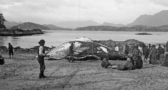
From late February onward, throughout the springtime, the migrating California grey whales would appear in Clayoquot Sound on their journey north from their winter breeding and calving grounds in Baja, California, to their rich feeding grounds in the Bering Sea. Their timing coincided with the arrival of the herring, for like so many other creatures, the whales feasted on herring roe, straining it through their baleen or scraping it loose near shore from the eelgrass and kelp. By April, the season of the whale hunt would begin, lasting two or three months.
The hunting of these grey whales, as well as humpback whales, set the Nuu-chah-nulth apart from other First Nations. Only they and the Makah people, farther to the south on the Olympic Peninsula, were “the people of the whale.” To participate in a whale hunt carried immense spiritual significance, as well as considerable danger. Hunters had to be carefully trained and ritually prepared; they abstained from sexual activity, cleansing themselves with elaborate cold-water bathing ceremonies before the hunt. The head harpooner underwent lengthier and far more rigorous preparations extending from November until April, cleansing and scouring his body and sea bathing in a highly ritualized manner, following intricate ceremonies and adhering to complex taboos. Toward the end, he retired to a powerful and secret shrine containing totems, skulls, masks, and other talismans, where he prayed and invoked the spirits to aid him in the upcoming challenge. A chief who inherited the role of head harpooner held a revered position within the tribe.
The whale hunt set forth in magnificent extra-large dugout canoes measuring from nine to eleven metres in length and up to two metres wide, carrying crews of between six and twelve: the harpooner, a steersman, and paddlers. One or more whaling canoes with a similar crew, each with a harpooner of lower rank, would accompany the main canoe carrying the head harpooner. Once they were out to sea and the hunters sighted a whale, the canoes positioned themselves so that when the whale came to the surface for air, the head harpooner, standing on the prow of the canoe, could thrust his three-metre-long harpoon just behind the whale’s front flipper. The head of the harpoon, attached to line made of whale sinew and cedar withes, embedded in the whale, and the yew-wood harpoon shaft came free. When the whale sounded, the line played out, and the crew ensured the smooth exit from the canoe of the four sealskin floats attached at intervals to the line. In 1858, William Banfield, the first settler and government agent who lived on the west coast of Vancouver Island, witnessed a traditional whale hunt. His colourful description, published in the Daily Victoria Gazette, noted how the whale sounded “at a great rate,” and that “the seal skins attached to him [tended] to impede and cramp his movements much.”
After the first harpoon thrust, the harpooners in the accompanying canoes joined the hunt. Each time the whale surfaced, a harpooner would be waiting to spear him, while paddlers and steersmen worked hard to keep the canoes out of reach of the whale’s violent struggle. Eventually, according to Banfield, the harpoons attached as many as forty or fifty sealskin bladders to the stricken whale, as it “beats and plunges in a fearful manner, overturning and breaking canoes.” As the whale lost strength, it dove less deeply each time it sounded, eventually staying at the surface, at which point the hunters “surround him… and goad him with their short spears until he becomes exhausted and dies.” A whale still capable of heading far out to sea could sometimes tow the canoe great distances, weakening all the time, before finally succumbing. If all went well, the whalers made their final kill without that happening. Then came the most gruelling challenge of all: towing a carcass the size of a semi-trailer back to their village—an extraordinarily arduous feat, accompanied by loud, rhythmic singing of “a song that would paralyze a strange white man,” in Banfield’s estimation. Peter Webster related how on one hunt his father and his crew harpooned a whale that towed them so far out to sea that “only the snow capped mountains were visible on the horizon.” The men, out of food, had to leave the whale and return to land to replenish their supplies before returning to tow it to land. “It would appear that the entire pursuit took two weeks from the beginning to the end.”
Having beached the whale at high tide in front of their village, the men flensed the whale, removing its blubber and meat, and distributed the pieces according to a strict protocol reflecting status and custom within the tribe. “The piece which is considered the most desirable,” stated Banfield, “is cut off for the chief and generally weighs about 100 pounds [45 kilograms]. The next in priority is the individual who first harpooned the whale.” Nothing went to waste. A successful whale hunt led to intense jubilation, and the hunters, hailed with traditional songs, dances, and ceremonies, gained great prestige. If they returned without a whale, or if accidents occurred during the extremely high-risk hunt, the people believed some taboo had been violated or one of the crew had not properly followed the purification rituals.
In July, sockeye salmon began migrating into the inlets and bays of Clayoquot Sound, heading toward their spawning rivers and streams. The Indigenous people followed, heading to their traditional inshore fishing territories. For the Tla-o-qui-aht, this included the mouth of the Kennedy River. There they caught the fish, mostly by using weirs and salmon traps, and either dried or smoked them. As the successive runs of salmon arrived in the inlets, the people would move with the fish from one area to another within their territory, collecting their harvest. By September, with the weather changing, the outer shore summer encampments stood mostly empty. The fishing activity now centred on the salmon streams. The final run of chum, or dog salmon, had very high value because the fish had less fat than other salmon so dried better for storage over the winter.
The Nuu-chah-nulth hunkered down for the winter months as the rain and storms restricted outdoor activity. Their winter villages varied considerably in size but generally had at least twenty longhouses, each housing several families. These structures stood at the tops of sloping sandy beaches adjacent to a supply of fresh water. The fragility of the cedar canoes made a sand or light gravel foreshore an essential feature for a village site. Huge cedar timbers and beams formed the permanent frame of the longhouses, with removable split cedar planks cladding the outside and the roof. Captain Cook described the Nuu-chah-nulth longhouses as resembling “a long English stable with a range of double stalls, and a pathway in the middle.” Totem poles sometimes graced the fronts of the longhouses, and carved house poles stood inside.
In 1791, John Boit, a sixteen-year-old officer aboard the American trading vessel Columbia Rediviva, wrote of the Tla-o-qui-aht chief’s house in his diary: “The house was large and commodious and wou’d hold fifty Indians very comfortably. All around were packages of fish in boxes decorated with pearl shell. The furniture consisted chiefly of matts and wooden boxes, which last serve to boil their fish in, which they easily do by applying red hot stones, till it boils. There were severall fires about the house but there were no chimnies and the smoke was too mighty for my eyes. They sleep on boards, rais’d about a foot from the ground and covered with matts, rolling themselves up in furs.”
Some of these large structures housing many families remained central to village life well into the twentieth century, only very gradually being replaced by individual dwellings for families. Peter Webster recalled his grandfather’s big house at Yarksis on Vargas Island: “It must have measured sixty feet by forty feet [eighteen by twelve metres]…constructed of boards on the outside and lined on the inside…with a big iron stove that was used for heating and cooking…I recall on many occasions falling asleep beside my grandfather while listening to his stories of the past and to the songs that were handed down.” These songs, so central in the cultural memory of the people, passed down from generation to generation: prayer and lullaby songs; others for dances, potlatches, and marriages; songs for bad weather and for funerals.
The storytelling and oratory that played an equally vital role in Nuu-chah-nulth culture also passed down from generation to generation. Great orators, respected as highly as great singers and dancers, inherited their stories, learning them from their fathers and grandfathers. Writing in 1868, Gilbert Sproat, one of the earliest colonial administrators on the West Coast, commented on the outstanding quality of oratory at large Nuu-chah-nulth gatherings. “The Clayoquot excel at public speaking…The voices of one or two noted chiefs are very powerful, yet clear and musical, the lower tones remarkably so; their articulation is distinct and their gestures and attitudes are singularly expressive…An actor or artist who wished to know what natural earnest manner in public speaking really is, should visit Clayoquot Sound…There is nothing to be seen in England like it.”
At all traditional gatherings, often with large numbers of people present, the songs, the oratory, and the dances expressed the accumulated wisdom and the history of the people. Recalling his grandfather Keesto, an Ahousaht hereditary chief, Dr. E. Richard Atleo (Umeek) wrote in his book Tsawalk: A Nuu-chah-nulth Worldview: “From his mother’s womb, according to ancient custom, he heard the songs and teachings about his ancestors, his identity, and his future promise as a chief. Through story and song, he heard and understood the meaning of his people, the meaning of his land, and the connection between spiritual power and the acquisition of resources for the wellbeing of his people.”
In the villages, with everyone gathered together, the winter season was a time for feasts, ceremonial dances, and for potlatches. “Potlatch” originates from the Nuu-chah-nulth verb pachitle, meaning “to give.” Generally potlatches took place during the winter to mark a significant event: the assumption of a chief; the official naming of a child; the maturing of a chief’s daughter; the eradication of a debt; and other landmark events. These lengthy ceremonies saw a leading member of a tribe inviting all of his people and often neighbouring tribes to feast, dance, sing, play games, and listen to long orations—and to receive gifts from the host. At potlatches, the host could part with everything but his house, and in doing so heightened his social status and reputation. Traditionally only the principal chief and the ha’wiih, hereditary chiefs, could afford to hold potlatches, but with the arrival of the Europeans, who brought with them a wide array of material goods and a cash economy, potlatching became more widespread. Believing potlatches to be heathen and wasteful, and fearing that large gatherings of aboriginals encouraged the spread of disease, the Canadian government outlawed the ceremony in 1884.
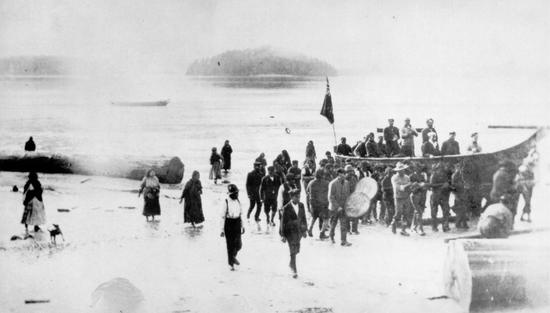
In the initial years of the ban, authorities tended to turn a blind eye. Harry Guillod of the West Coast Indian Agency proved to be one of the most sympathetic of all Indian agents, writing in 1885, “No doubt there is some waste at these meetings, where a canoe full of cooked rice and several sacks of sugar, or six or eight boxes of biscuits are distributed, but the poorer Indians reap some benefit from it, and all carry away what they cannot eat.” The Presbyterian missionary John Ross, for many years based at various West Coast locations, including Ahousaht and Ucluelet, left a vivid description of a potlatch he attended in the early 1900s. Ross described the vast quantities of rice being cooked in huge iron kettles, stirred by canoe paddles, and later served with fish, apples, and biscuits to the assembled guests. Looking around, Ross noted the timeless quality of the event, the size of the longhouse with its “huge posts supporting the beams [which] were carved totems,” and the convivial atmosphere. “The Indians were all decked out in paint and feathers,” he wrote, “their heads covered with white down which is always a sign of peace…Two large fires were burning brightly and with the light of the fires and lanterns hung here and there around the building there was a feeling of comfort also as the rain was pouring down outside and the wind blowing a south-easter. We could hear the waves rolling up on the beach which all added to a sense of cosy comfort and real interest as we watched the natives enjoying themselves in one of their ancient customs.”
The Nuu-chah-nulth First Nations all shared a similar social and political structure, a hierarchical system based on inheritance that conferred status within the tribe. The hereditary chiefs, or ha’wiih, each with a fixed rank and responsibilities and privileges, came under the leadership of a principal chief, the taises or tyee. Each ha’wiih had his own ha’houlthee, or chiefly territories, and taken all together these formed the ha’houlthee of the tribe. The taises, like the others, inherited his position from his father; his role required consultation with the ha’wiih, elders, and heads of families to reach consensus on important matters.
At the time of European contact, the taises held great power, claiming ownership of all the tribal territory as well as its resources: the village sites and houses, the salmon streams, clam beds, herring spawning grounds. The principal chief’s younger brothers served as minor or sub-chiefs, acting as war leaders, ambassadors, or orators. Each First Nation operated somewhat differently; the numbers of hereditary chiefs and their designated roles varied from one territory to another. Consistently, though, the clear hierarchy among the chiefs and within families played a crucial role in the daily lives of all Nuu-chah-nulth people. This hierarchy determined status, ceremonial roles, responsibilities, and place in line when riches like whale meat and blubber were distributed.
Up to a quarter of any given tribe could be made up of slaves, usually taken in wars with nearby tribes. The slaves did much of the work and lived as part of the family group that owned them. They could be well treated or shamefully treated; their lives rested on the whim of their owners, who could sell, ransom, trade, or kill them as they saw fit. To become a slave brought disgrace, especially if the victim had to serve someone of lower rank. Many tried to escape; if caught, the penalties could be dire.
Intertribal warfare pervaded northwest coast society; slave raids, revenge, or territorial raids being the main motivators. Using the element of surprise, attacks took place at night or at dawn; the attackers could be few or number in the hundreds. Once in the enemy’s camp, they killed as many men as possible, sometimes decapitating them. Women and children fled or were taken as slaves.
The most significant war in Clayoquot Sound occurred only decades before Europeans arrived on the coast. As mentioned earlier, in this war the Tla-o-qui-aht, allied with three or four other tribes, wiped out the Esowistaht on the Esowista Peninsula. Afterward, the Tla-o-qui-aht chief Ya’aihlstohsmahhlneh (who later took the name Wickaninnish) redistributed Esowistaht territories and possessions to his relatives and allies, whom he urged to come and live with him at Opitsaht. This war consolidated Wickaninnish’s position as the dominant chief in the Clayoquot Sound area.
Following European contact, Wickaninnish continued to expand his influence over neighbouring tribes through warfare, and he monopolized commerce with traders who visited Clayoquot Sound. Once he had access to firearms, he used them to control trade and subjugate tribes to the south in Barkley Sound. Around 1792, a member of the Hatc’a’atHa tribe in Barkley Sound killed a Tla-o-qui-aht, and Wickaninnish retaliated by attacking the tribe. Even though the Tla-o-qui-ahts had guns, the Hatc’a’atHa laughed at them, believing such objects were only for frightening, and that they could not kill. According to Daniel Clayton in The Imperial Fashioning of Vancouver Island: “The Tla-o-qui-aht never raided twice, but always wiped out the enemy in a single raid, because they knew how to fight”; after the raid “no one was left of the Hatc’a’atHa.”
Up to the early nineteenth century, the Ahousaht had been a relatively small tribe and not wealthy. Crucially, their limited territory on the western side of Vargas and beneath Catface Mountain held no salmon streams. Despite intermarriage with the Otsosaht, who had rich fishing grounds on Flores Island and up Herbert, Shelter, and Sydney Inlets, the Otsosaht would not allow the Ahousaht to fish there. Tensions mounted gradually between the two tribes. Several ugly clashes and skirmishes led to a number of grisly deaths on both sides, and eventually to a major attack in which the Ahousaht killed and decapitated eighty Otsosaht. This occurred at night, when the Otsosaht were asleep at their summer fishing camp on the northwest tip of Bartlett Island. The blood-soaked hostilities dragged on for many years in a series of raids on villages and attacks on fishermen, with the smaller Ahousaht group gradually gaining dominance as they killed ever more Otsosahts. In all likelihood, the Ahousaht’s strength lay in their firepower; they had acquired firearms and ammunition through their allies the Mowachaht and Nuchatlaht, farther up the coast. In the end, the few remaining Otsosaht moved permanently out of Clayoquot Sound, taking up residence along the coast of Washington and Oregon. Following their departure, the Ahousahts divided the rights to the eighteen salmon rivers in Otsosaht territory among themselves and their allies, including the Kelsemaht, the Owinmitisaht, the Quatsweaht. The Ahousaht took over the Otsosaht winter village Maaqtusiis, making it their principal village.
In 1855, war erupted between the Tla-o-qui-aht and the Kyuquot, farther up the coast beyond Nootka Sound. The killing of a half-Kyuquot and half-Tla-o-qui-aht woman precipitated the conflict. The murderer confessed to the crime, and the Tla-o-qui-aht used this as a reason to attack the whole Kyuquot tribe, building on former hostilities. Tla-o-qui-aht chief Sitakanim united the Hesquiaht, Mowachaht, Ehattesaht, and Cheklesaht in this enterprise, and they all assembled on an island near the two Kyuquot villages. Leaving some men to guard the canoes, at midnight the attackers crossed a spit to where the Kyuquots lived. Sitakanim and his men surprised the sleeping Kyuquots, killing them on their mats and setting fire to their longhouses. Accounts of the number killed vary considerably. Father Augustin Brabant later reported as many as seventy Kyuquots lay dead after the raid, many with their heads removed. Gilbert Sproat put the number at about half that. The Tla-o-qui-aht took the heads of the slain Kyuquot back to Clayoquot Sound, along with some twenty slaves; the heads, displayed on poles on the Stubbs Island sandspit, remained there for years afterward.
The first permanent European resident at the Clayoquot trading post on Stubbs Island, trader Fred Thornberg, wrote of finding skulls on the sandspit when he arrived there in 1874. According to Thornberg, who revelled in dramatic storytelling, the beheadings had continued right there on Stubbs Island, with Chief Sitakanim decapitating all the prisoners he had taken: “Chief Ceadarcanin [sic] alone went on the Spit and finding a suitable place for what this Devil was going to doe, he comandet his men to bring one by one these prisoners on shore to him & they done so. And Ceadercanin alone cut the Head off these 18 Ind. And there head was then stuck on to a small poles & they were stuck in the Sand.” Thornberg claimed that the chief bragged to him about decapitating his enemies, saying he used a large mussel shell about seven inches [17.5 centimetres] long, honed on a rock to razor sharpness.
The days of tribal warfare in Clayoquot Sound waned, disappearing altogether following the mid-nineteenth century. Broader social and economic upheavals eclipsed intertribal conflicts after that. The emerging settlement of Fort Victoria swelled in importance and size, its influence rippling up the West Coast. More and more trading vessels visited the coast, seeking furs and dogfish oil, and in scattered coastal locations permanent trading posts came to stay. Gunboats of the Royal Navy appeared along the West Coast, occasionally engaging in fearsome displays of power and authority. And as ever more Europeans drifted in and out of Clayoquot Sound, they brought with them more change, more trade goods, and more alcohol. They also brought more disease.
In 1856, the combined European population of the settlements of the Victoria district, Nanaimo, and Fort Rupert (Port Hardy) stood at 774. The estimated Indigenous population of the whole of Vancouver Island was nearly 26,000. With the introduction of venereal diseases, measles, whooping cough, typhus, typhoid fever, tuberculosis, and the worst scourge of all, smallpox, the Indigenous population would be reduced by almost 90 percent by the end of the nineteenth century. Most died of smallpox.
Smallpox had already laid waste to millions of lives in the Americas. It arrived with the first explorers and immediately began devastating the Indigenous populations of Mexico, Peru, Cuba, Hispaniola, and Puerto Rico, wiping out an estimated 50 to 90 percent of the locals. That first epidemic, at least in part, made it possible for Hernán Cortés and his 300 conquistadores to conquer the Aztecs in 1520. It killed an estimated 15 million Mexicans, half of the population, and claimed an estimated one-third of the Indigenous people of North and South America. In the 1770s, smallpox struck again, this time in the Missouri River Basin, spreading westward along Indigenous trading routes to the Pacific coast, hitting the northwest coast in 1775–1782. Captain George Vancouver, on his voyage in 1792, found many deserted villages in Puget Sound and the Strait of Georgia. A third epidemic, from 1835 to 1838, cut a swath from California up the Pacific coast as far as the Aleutian Islands, killing about one-third of the population of northern tribes, including the Haida, Tlingit, and Tsimshian, as well as affecting the population of Clayoquot Sound.
The most recent and, for British Columbia, the worst smallpox epidemic began in New Westminster in March 1862, brought by a steamer passenger from San Francisco. Victoria’s British Colonist misleadingly stated in its March 22 edition: “The case is not considered serious.” By the 1850s, early forms of immunization against the disease existed, but with no effective means of quarantine among Indigenous people, the disease rapidly escalated out of control. Within a year it killed some 32,000, or over 60 percent, of BC’s Indigenous population.
When smallpox reached Victoria in April 1862, the nearby Indigenous encampments bore the brunt of the affliction. Because many people from North Coast First Nations migrated down to Victoria each spring seeking trade and employment, an estimated 2,000 or more Indigenous people from up the coast could be found living near Victoria, including large groups of Haida, Tlingit, and Tsimshians. As the infection rapidly spread among them, fear escalated in the settler population, fuelled by commentary in the British Colonist, then edited by future provincial premier Amor de Cosmos. On April 28, 1862, an editorial demanded that in order to protect whites “from the pestilential scourge that is hovering among the savages on the out skirts of the town,” all Indigenous people be removed “to a place remote from communication with the whites, whilst the infected [Indian] houses with all their trumpery should be burned to ashes.” Commissioner of Police, Joseph Pemberton, took action. Within days, the authorities burned the villages and encampments around Victoria, forcing the northern people to leave. The gunboats Grappler and Forward implacably assisted in the exodus, with Forward towing twenty-six canoes full of infected people back to their home villages.
This enforced departure spread the disease to villages up the coast from Victoria to Alaska, and before long infection spread to First Nations along the Skeena, Fraser, and Nass Rivers and into the province’s interior. The death toll rose relentlessly, wiping out whole villages, leaving many abandoned, and causing some bands to amalgamate in order to survive. On June 21, 1862, the British Colonist foresaw this outcome, and showed no compunction, particularly in relation to the warlike Haida: “How have the mighty fallen! Four short years ago, numbering their braves by thousands, they were the scourge and terror of the coast; today, broken-spirited and effeminate, with scarce a corporal’s guard of warriors remaining alive, they are proceeding northward, bearing with them the seeds of a loathsome disease that will take root and bring both a plentiful crop of ruin and destruction.”
“These mass deaths [from the 1862–63 epidemic] tore irreparable holes in the cultural fabric of societies in which oral traditions were the custodians of the genealogies, laws, histories and literature of entire peoples,” wrote Stephen Hume in the Vancouver Sun on the 150th anniversary of the epidemic. On Vancouver Island’s once densely populated west coast, First Nations faced near annihilation of their structured, long-established way of life. And yet, cataclysmic though they were, the various smallpox epidemics represented only one of the disasters unleashed on the people. Simultaneously, into their world came heavily armed strangers determined to impose their mores, institutions, and religion on the local people. All too often these strangers assumed that the land, with its complex traditional territories and its hierarchical, deeply rooted patterns of ownership and use, could be theirs for the taking. Today, nearly 250 years after the initial contact between the First Nations and Europeans, the consequences of such assumptions and such actions continue to be played out in Clayoquot Sound and elsewhere. The processes of recovery and reconciliation still have a long road to travel.