- EBC Home
- Subjects
- Index
- About the EBC
- Using the EBC
- Maps
- Feature Articles
- Videos
- BC Facts
- For Teachers
- French Language Resources
- Books about BC
- BC Links
![]()
![]()
Rivers
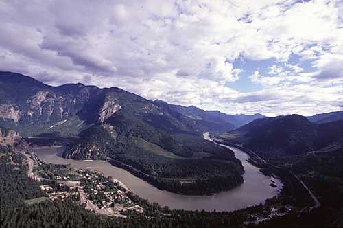
RIVERS are extremely important in such a mountainous place as BC. They have played, and continue to play, a major role as agents of erosion and shapers of BC's landforms. They cut through mountain ranges, allowing access for people and providing migration routes for spawning SALMON and many other plant and animal species. As well as providing food and settlement areas, they offered a primary means of transportation for FIRST NATIONS people and were the routes followed by railway and highway construction. Rivers were the principal means by which BC was discovered, and exploited, by early explorers and settlers. Rivers facilitated major GOLD RUSHES, and the historic explorations of Alexander MACKENZIE, Simon FRASER and David THOMPSON were conducted down the uncharted rivers that today bear their names. Many of BC's rivers support globally significant salmon populations, as well as opportunities for development of HYDROELECTRICITY. They provide water for AGRICULTURE and industrial and domestic uses, and contribute substantially to the provincial ECONOMY.
BC has 5 major drainage systems: Yukon, PEACE–LIARD (Mackenzie system), COLUMBIA, FRASER, and the coastal system, which is made up of the drainage basins of large and small coastal rivers such as the SKEENA, STIKINE and NASS; these drainage basins are separated by heights of land. Two-thirds of BC's rivers drain to the Pacific Ocean, while the rest drain north to the Yukon R or northeast to the Mackenzie R. It can also be argued there is a sixth system: the Flathead R system has a headwaters branch in BC's southeast corner. Its watershed is largely in Montana and it drains into the Missouri–Mississippi system and ultimately to the Atlantic Ocean. This area is called CROWN OF THE CONTINENT in large part because of this major drainage divide.
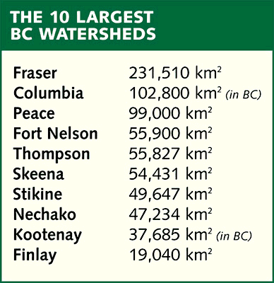
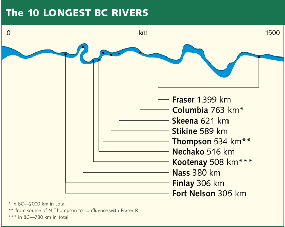
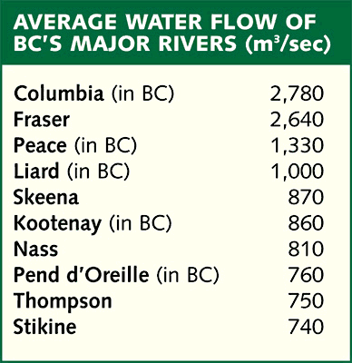
The northwestern corner of BC lies within the drainage basin of the Yukon R. Large lakes such as Atlin, Tagish and TESLIN are part of this system, which rises in the Jennings Lks in the western end of the Cassiar Mts and is fed by the rivers, LAKES and icefields from Atlin to Teslin lakes. The Liard and Peace rivers and their tributaries are part of the Mackenzie R system and drain about 260,000 sq km of northern and northeastern BC. The headwaters of the Peace and the confluence of the FINLAY and PARSNIP rivers were forever altered during the 1960s by construction of the BENNETT DAM and creation of WILLISTON RESERVOIR. Of the major drainage basins, only the Fraser's is completely within BC. From its headwaters at Moose Lk in Mt ROBSON Provincial Park, to its massive ESTUARY at the Pacific Ocean, the Fraser runs 1,399 km. At about 231,500 sq km, its drainage basin is second in size to the area drained by the Peace–Liard system. As with most of BC's river systems, the Fraser was shaped and successively altered by massive GLACIATION, deposition and subsequent uplift. There is believed to be a close geological linkage between the upper Fraser (as far as McGREGOR), the Peace and the ROCKY MT TRENCH, but the record of stream piracy is lost in the meltwaters of time. The Columbia R rises in Columbia Lk, flows northward around the top of the SELKIRK MTS, then turns south, draining about 102,845 sq km within BC before flowing into the US. The KOOTENAY R, its major tributary, also loops north and south, giving evidence of more stream piracy and a drainage history as complex and equally lost in the geological past as the Fraser's. The fifth drainage system is represented by a number of rivers in the western part of BC that rise on the east side of the COAST MTS and drain most of northwest BC. The 4 largest of these are the Skeena, Nass, Stikine, and TAKU rivers. Geologically they have maintained their courses across the Coast Mts and, with their steep gradients, have expanded their drainage basins at the expense of the other systems that surround them. In time, for instance, the headward expansion of the Taku's tributaries will eventually take over much of what is currently drained by the Yukon R. BC's rivers are truly dynamic. See charts listing BC's 10 longest rivers and largest watersheds.
by Maggie Paquet
Reading: Stuart S. Holland, Landforms of British Columbia, 1976.
-
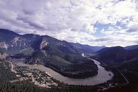 The Fraser R at Yale. Rick Blacklaws photo
 -
Charts and graphs