- Contents
- Preface
- Acknowledgements
- Introduction
- Chapter 1
- Chapter 2
- Chapter 3
- Chapter 4
- Chapter 5
- Chapter 6
- Chapter 7
![]()
![]()
2. Empty Land or Stolen Land? The Colonial Strait
As many as 50,000 people, perhaps more, lived around the North Salish Sea (Strait of Georgia) before the onset of epidemics in the late eighteenth century. Sustained by an abundance of food from the sea, this was a relatively dense population compared with those in other parts of pre-contact North America. Salmon spawning in streams around the Strait, in particular the immense Sockeye salmon runs of the Fraser River, were the basis for sophisticated fishing technologies that had given rise to a culture and an economy constructed around these fish. Herring appears to have been as fundamentally important for Indigenous people farther north on the Strait as salmon were to those living near the mouth of the Fraser.
Most Indigenous communities around the inland sea were located on beaches at the mouths of streams. These locations reflected the importance of marine food sources as well as considerations about ancestors and other social, political and defensive concerns. Many seasonal settlements—especially on islands—were in places well situated for harvesting shellfish and camas root, hunting marine mammals and birds, and fishing. Autumn camps were at river mouths for the return of the salmon. In the coldest, wettest months, most people congregated in larger settlements, often in sheltered coves and inlets beside beaches that were protected from winter storms and could be more readily defended against marauders for whom the Strait’s protected waters were a convenient highway. Marine harvests were usually plentiful, which brought wealth and gave people time for recreation and artistic expression.
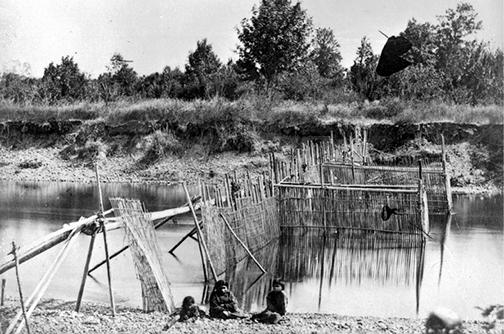
Pre-colonial society on the Strait was tied together in various ways. Most people around the sea spoke languages of the Coast Salish group, which extended south into Puget Sound (the South Salish Sea) and west onto the shores of the Strait of Juan de Fuca (the West Salish Sea). They were also linked by networks of marriage and elaborate systems of economic cooperation and ceremony. Virtually all resources of the sea and adjacent shore were controlled by a particular community, family or individual. And in a preliterate society, tying these natural resources to cultural property such as names, songs and roles in traditional ceremonies helped people to remember and communicate the elaborate webs of ownership and culture. These were ways to pass along knowledge about marine resources and harvesting technologies such as the shellfish gardens and tidal weirs in places such as the Comox estuary, and Cortes and Quadra Islands.
Society around the sea was hierarchical and knowledge based, but much of this complex traditional knowledge was not shared common property; instead, it was what we would call “intellectual property” vested in individuals, families and kinship groups. High- and low-status people and slaves knew their places and roles in society. High-status people had detailed knowledge of their genealogical history; low-status and slave people were deemed to have forgotten theirs. When waves of epidemic disease ravaged the Strait’s population, they diminished people’s capacities to pass on orally transmitted knowledge that belonged to them.
The seeds of change for the Strait’s Indigenous people and the onset of their catastrophic losses were sown prior to European colonisation. Their sea was on the margins of the eighteenth-century geopolitical struggles that played out on the northeastern Pacific Ocean once other countries learned of Russia’s secretive, and extremely lucrative, sales of sea otter furs in China. The Strait’s Indigenous people did not participate in this brisk trade though it affected them indirectly, as their traditional rivals to the north and west grew stronger by participating in it. Nor were the Strait’s people directly affected when Britain’s Hudson’s Bay Company (HBC) lost control of the Lower Columbia River basin to American immigrants before 1850. But they began to feel the impact of these power struggles when the HBC reinforced its claim to Vancouver Island and a stretch of Mainland shore tucked between the expansive American and Russian empires. Outsiders arriving on the inland sea before mid-century were almost all employees of the HBC, which moved its centres of operation north from the Lower Columbia to the Lower Fraser and the southern tip of Vancouver Island.
The HBC was not keen on uncontrolled European settlement around the inland sea. The company aimed instead to maximise its profits by trading with Indigenous people. So when Britain began discussing settlement of Vancouver Island in the 1840s, the HBC occupied an ambiguous position. It had unique knowledge of the local Indigenous people and their rich resources, but the company’s relations with these people and their place might not match the needs of the Empire’s colonisation plans. Royal Navy lieutenant Adam Dundas reported to the British Colonial Office that the HBC was interested only in promoting its own interests and did not need colonists; instead, it needed to trade with the “Savages.”1 The well-established company found itself in limbo between the Indigenous people’s old world and the settlers’ new one, and its dominant role would not continue long into the settlement era. Its efficient trading system, on the other hand, was instrumental in ushering in much change on the Strait.
Although the HBC did not control the Strait before the mid-nineteenth century, it had established discrete centres of power inside the walls of its forts there. More importantly, the company had introduced a system of exchange that linked the Strait to distant markets hungry for its minerals, fish and wood. In the decades before colonisation, the HBC depended almost wholly on Indigenous labour. Between 1800 and 1850, a few hundred Canadians, Brits, Hawaiians, Métis and Chinese people—almost all men—lived among thousands of Indigenous people around the inland sea. Salish-speaking people worked to control access to the HBC’s forts, excluding whomever they could and exercising their own forms of control over these valuable power objects. So the local Lekwungen people welcomed the arrival of European traders in Victoria because they saw these well-heeled newcomers as proof of their own spiritual power. The traders enabled the Lekwungen to convert readily available local resources into precious blanket currency.
As settlers replaced traders after 1850, they encountered Indigenous communities traumatised by a gauntlet of epidemics that had started decades earlier. Looking at anomalies in the archaeological record, some researchers suspect that periodic scourges of exotic disease may have begun on the Strait as early as the sixteenth century. Smallpox probably spread along trading routes from central Mexico, reaching the Strait in the 1780s. In the 1790s, British navigator George Vancouver found the shores of the inland sea lined with deserted villages and human skeletons. Such epidemics may have recurred along the coast up to eight more times between 1800 and the 1860s. By 1850, previously isolated populations with little inherited resistance had suffered a lethal mix of chronic and epidemic diseases, including tuberculosis, smallpox and measles. Similar epidemics had already transformed most of the western hemisphere. The early nineteenth-century Strait of Georgia might be described, as historian Shawn Miller depicted sixteenth-century Latin America, as a place where “disease conquered the human species.”2
Evidence of demographic collapse around the Strait is still being uncovered. Archaeologists Nancy Greene and David McGhee have spent a decade examining and documenting tens of thousands of Douglas fir stakes 15 centimetres in diameter, spread over several kilometres of tidal flats in the Comox estuary. The stakes outline a large number of sophisticated fish traps capable of catching vast quantities of groundfish, salmon and other species. Carbon dating suggests that many large traps operated simultaneously, the oldest dating back almost 1,400 years, the most recent to the 1840s. Infrastructure of this scale would have fed—and required collaboration by—Indigenous populations far larger than those in the Comox area at the time of European settlement.
Geographer Cole Harris estimated in Resettlement of BC that populations on the Strait fell 90 to 95 percent in the century after the 1780s, which is similar to the decline estimated for Mexico’s Indigenous population during its first century of contact with the Spanish. Without reliable statistics on death rates for specific epidemics in individual communities, there is no consensus on the numbers and there likely never will be. However, disease appears to have reduced the Indigenous population on the inland sea to a far greater extent than the infamous plagues that killed between a quarter and a third of Europe’s population in the fourteenth century. Unlike Europeans after the Black Death, the Strait’s Indigenous people, caught up in a tide of change beyond their control, had no opportunity to rebuild their own shattered societies. By 1850, travellers around the Strait reported streams and shorelines bursting with fish. Their stories helped make the place an attractive candidate for integration into global trade networks and a destination for Victorian settlers and sportsmen. The bounty they described was at least in part the result of the rapid decline in Indigenous fisher populations.
Declining Indigenous populations coincided with Britain’s growing interest in colonisation and the Royal Navy’s desire for a strategic foothold in the northeastern Pacific. London was responding not just to the American takeover of the Oregon Territory but to a global list of alarming developments, from starvation in Ireland and rebellion in Upper and Lower Canada to ongoing Russian and American expansion. As one rationale for the colonial project, British officials cited the need to impose the civilising rule of the British Empire to protect settlers from Indigenous groups and Indigenous groups from each other. Archaeological evidence suggests that the inland sea, like the Mediterranean and Baltic regions in earlier times, had been a relatively stable place where coastal communities engaged in endemic warfare of different kinds. Most of this conflict was local, more often involving seizure of property rather than conquest of territory. Yet the Strait has clearly been contested space for a long time.
Many signs of conflict and defensive alignment among shoreline communities appear in the archaeological record. Quadra Island historian Jeanette Taylor and other writers have described the elaborate defensive fortifications, escape tunnels and trenches the Salish-speaking Comox people developed around the northern Strait to defend themselves from Kwakwaka’wakw and Haida speakers arriving from the north. This inter-regional level of conflict may have intensified as European contact in the nineteenth century tilted the balance of power away from the Salish speakers of the inland sea; Salish speakers’ military strength was clearly waning during the decades after first contact.
In the 1790s, the northern boundary of the Salish-speaking region probably extended beyond Kelsey Bay, well past the north end of the Salish Sea. The Kwakwaka’wakw-speaking people may have lived beyond the reach of the first epidemics sweeping the Strait in the late eighteenth century. These northern people also benefited more from the rich sea-otter trade and the advanced weapons it financed. By the mid-nineteenth century, the Kwakwaka’wakw speakers had moved much farther south and were established on Quadra Island and mixing with dwindling Salish-speaking communities as far south as Comox and Qualicum. Violent confrontations between the two language groups continued in the first century after European contact and were cited to help justify colonial rule.
Land hunger was a more important impetus for British colonialism than local peacemaking. This was an era in which Europeans were rushing into “unoccupied” lands in many parts of the world. As they had been doing elsewhere since the sixteenth century, the settlers applied “colonial assumptions of progress, superiority and civilisation”3 to the Strait’s Indigenous societies and then imposed their own new order, rules and laws. This process had evolved and increased in efficiency for over three centuries before it reached the northwest coast of North America. It was particularly robust in the final decades of the nineteenth century, when it coincided with the growth of laissez-faire economic policy and the final wave of European colonial expansion.
The Strait’s Indigenous communities had highly developed systems of control over space and, in particular, over marine resources. But individual ownership of land—a dominant preoccupation among arriving settlers—had no meaning for Indigenous people. Even in those few cases when early settler governments reimbursed them for land around the Strait, Indigenous people apparently understood they were accepting settlers’ goods in exchange for the right to use particular resources, not granting the alien notion of “perpetual exclusive ownership” of land.
Colonisation on the Strait focused on gaining control over land and resources and imposing settlers’ rules for governing these. With this process came a change in the perception of land and resources from things that could be used by certain clans or groups to things that could be permanently, legally owned by individuals. The European concept of “improvement” was a key element in this transformation. Land improvement as a basis for establishing ownership had deep roots in British common law. To improve land was to take idle land—land whose productive potential was being “wasted”—and render it fruitful. Used as a rationale for the English seizure of Irish lands in the seventeenth century, this process of “converting frontiers into assets” was applied in other regions colonised by Europeans.4 This shift in perception was at the core of the Strait’s dispossession process and, as in many other places, it was accompanied by dramatic changes in the way land and resources were used. The region could hardly have been said to be empty of settlement before European colonisation, though this was sometimes suggested. It was far easier to maintain that most of the land around the Strait was not bearing fruit in the way it could be under European tutelage.
An official declaration of sovereign control over all land and people inhabiting the Strait was a prerequisite for subsequently applying settlers’ property laws. The British Empire made this claim first and then passed it on to the government of British Columbia when the colony joined Canada in 1871. And though the federal government was assigned control over Indigenous people, it would continue to haggle with the province for decades after Confederation over what lands BC’s Indigenous people should have. In fact, the process of establishing settler control on the Strait was broadly similar to other nineteenth-century colonisation projects around the world, from Algeria to Australia. What they all had in common was an intense land hunger among white European settlers that was initially characterised by relatively fluid relations between colonisers and colonised in which land was acquired through formally negotiated purchases. This approach prevailed during the first decade of colonisation on the Strait. Later it shifted, as it had elsewhere, to “firm, unilateral, overpowering, subordinating and anger provoking applications of sovereign power.”5
The Strait’s transformation also involved dramatic ecological change. Experiences with colonial expansion elsewhere again offer useful insights. Spanish colonists introduced intensive pastoralism to the Mezquital Valley of Central Mexico in the sixteenth century, and it rapidly replaced an Indigenous system of irrigated agriculture that had supported dense populations. Just as this Spanish colonial technology marginalised the Mexican Indigenous population, rendering people unable to support themselves as they had in the past and greatly diminishing their future options, the industrial fishery controlled by British settlers rapidly displaced and marginalised the Strait’s Indigenous people.
Although early European travellers in the western hemisphere often talked about having entered a “New World” in the Americas, it was in fact a very old one. It was only after Europeans arrived and complex relations evolved between them and the very old societies that were already established on these lands that a new world really began to emerge. In Latin America, this process took a century after European arrival. It took about as long on the Strait of Georgia. First came a trading relationship, then a few decades of colonisation followed by the arrival of the railway and the beginnings of mass immigration in the 1880s.
The establishment of imperial control of the Strait, 1849–1880s
Once the world’s other empires recognised Britain’s claim over a stretch of the northeast Pacific shore, settlers were needed to secure its control. James Fitzgerald, writing to the Colonial Office in 1849, was more optimistic than some about the prospects for settlement: “It seems difficult to overrate the rapidity with which trade might increase if an industrious and persevering race were to establish themselves on the Northern Shores of the Pacific Ocean.”6 This settlement would be part of the second great wave of European imperialism that gave rise to, among many other things, an energetic republican American empire and a less populous Canadian federation tied to Britain, with its own dreams of westward expansion.
Disease and disappearance
Settler society on the Strait was not destined to be a hybrid spawned from its old and new worlds. The settlers simply aimed to replace Indigenous societies with their own. Underestimates of the Indigenous population may have guided colonial policy from the beginning; a report to the Colonial Office in 1849, for example, suggested all of Vancouver Island contained 5,000 “Natives.”7 The actual number was probably higher at the time, yet disease would help low estimates like these become more accurate. A final smallpox epidemic in the early 1860s swept through Indigenous communities, killing an estimated 15,000 people, a very large proportion of the total population of the new colonies of Vancouver Island and British Columbia. By the late 1860s, many Europeans spoke of travelling through an almost empty Strait, with only the occasional Indigenous cooking fire, canoe or camp. A surveyor named George Drabble, who travelled widely around the northern Strait between the 1860s and the 1880s, reported seeing many deserted Indigenous houses and villages.8 Meanwhile, arriving settlers were hungry for land and for the Strait’s abundant and seemingly untouched resources. If the people who had once considered these places their own were no longer visible, then these traces of past occupation—abandoned houses, burial grounds and camas pastures—could be safely ignored. The Strait’s settlers were more inclined to see themselves as building a new outpost of European civilisation on an empty landscape.
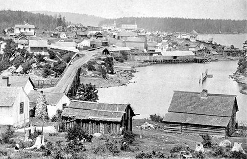
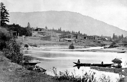
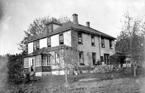
By the 1870s, settlers were concentrated around New Westminster and Victoria and still numbered less than 11,000, or about a third of the new province’s overall population, with Indigenous people accounting for about two-thirds. Settler sawmills, mines and farms controlled considerable space and resources around the Strait, while the HBC had receded into the background. And by the early 1880s, when the transcontinental railway was a certainty though not yet completed, most of BC’s population was concentrated on or near the Strait. Indigenous people remained the majority of the province’s population into the mid-1880s but not around the inland sea. For example, the Cowichan people, who had numbered an estimated 5,000 in the early 1800s, had fallen to 500 a century later. It was a rapid and dramatic transformation (see painting here and photographs here, here and here) though a relatively peaceful one.
This decline of local Indigenous people did not arouse much sympathy among settlers. As settler communities grew and became more self-sufficient, the remains of Indigenous societies became more “strange” to them. When they were not working for settlers, Indigenous people now mostly lived on reserves, places that were beyond the pale for most settlers. Settlers increasingly looked upon the reserves’ occupants with irritation or contempt, and “half-breeds” born of settler and Indigenous parents aroused particularly strong disapproval.
In the same way that settlers were given places around the Strait as though no one else had any claim to them, places were given new names as though they didn’t have names already. The British sprinkled English renditions of Indigenous names—Sechelt, Comox, Qualicum, Nanaimo, Cowichan, and so on—across their maps, but a great many places were summarily renamed in honour of distant patrons, friends or mistresses. It wasn’t just ancient Indigenous names tied to local people and stories that got erased. Whereas the Spanish had called the Strait “El Gran Canal de Nuestra Señora del Rosario la Marinera,” Captain Vancouver rechristened it the Gulf of Georgia in honour of his monarch, King George III. Other places around the Strait were renamed for more immediate symbols of imperial power and authority: British sailors and their ships. Oral historian Imbert Orchard commented on the “nobility” imparted by the new names around Jervis Inlet, where Prince of Wales Reach extended into Princess Royal Reach, below Mount Victoria and Mount Albert, in the vicinity of Mount Wellington, Mount Churchill and Marlborough Heights.9
Pax Britannica
British military experts reported in 1849 that the Indigenous people of Vancouver Island were “numerous, well-armed, brave and warlike” and might pose a significant threat, and they called for British troops and ships to protect future settlers.10 By 1859, settlers in Victoria often seemed less worried about Indigenous people than about their American neighbours, who officials feared might “wrench the keys to the Gulf of Georgia from our hands.”11
During the early years of European settlement, Indigenous men around the sea did in fact pose a significant threat of violence but mostly to other Indigenous people. The record after 1850 abounds with settlers’ stories of violence between First Nations, most often between locals and northern intruders. An alliance of Salish speakers attacked northern raiders at Maple Bay around 1850, killing most of them. The survivors wreaked havoc on Comox villages as they returned north. Two years later another murderous attack on northern interlopers, by Sechelt warriors this time, was reported north of Nanaimo. Several years later, settler Adam Horne reported “one of the most gruesome massacres in our Island’s history” at the mouth of the Qualicum River: Haida flaunted the severed heads and scalps of slaughtered Qualicum men as they paddled onto the Strait with the women and children taken as slaves. A handful of Bella Bellas were trapped and massacred by Cowichans in Ganges Harbour in 1860. Other Bella Bellas, ordered out of Victoria by Governor James Douglas in 1861, staged a surprise attack on the Penelakut people on their way north. Over 200 Penelakut were slaughtered in “one of the worst massacres recorded.”12 The British navy pursued the marauders north to Discovery Passage, where they fired a few volleys into the Bella Bella camp but couldn’t arrest their leaders.
Such carnage witnessed, or more often heard or read about, helped confirm settlers’ notions about the savage nature of Indigenous people. In their minds, it seemed clear these were uncivilised people who needed British law to protect them from one another. Or as local Indian Commissioner G.M. Sproat remarked to the Minister of the Interior in Ottawa in 1876: “The occupation of the country by the whites was attended by one great advantage to the Indians. It stopped the constant inter-tribal warfare, which every year caused the deaths of several hundred men in the prime of life.”13 While Indigenous people on the Strait suffered from ongoing intertribal violence after mid-century, the substantial threat to early settlers predicted by the British military didn’t materialise, beyond a few incidents. The Colonist suggested in 1861 that, while the capital could probably take care of itself during an uprising, colonists on the Strait itself would need protection.14 Yet the “Indian threat” to settlers on the inland sea was ambiguous at best, and much diminished by disease. Even intertribal warfare declined steeply with the last great epidemic.
Although many settlers saw Indigenous people as difficult to live with, they couldn’t really live without them either. Rear Admiral Joseph Denman’s gunboats were called out more than once to protect Comox Valley settlers who felt threatened by Lekwiltoks from Quadra Island who had come to fish on the Comox estuary. When Denman arrived to drive them off in 1865, however, settlers prevailed upon him to leave the Indigenous people alone, because their labour was sorely needed on settler farms. Settlers also depended on them for fish and venison.
By the mid-1870s, unrest was on the rise again among Indigenous people. It was being fanned largely by growing discontent over the new province of British Columbia’s intransigence towards First Nations’ demands for land. Stories of violence among Indigenous groups also reappeared. Sproat reported in 1876 that Indigenous people from Barclay Sound had crossed the Island and massacred “20 or 30 Punt-lahtch” people at Comox.15 A year later the Nanaimo Free Press published a rumour about a canoeload of Queen Charlotte people murdered near Plumper (Active) Pass in revenge for a number of Cowichan murdered by northerners.16 These stories about Indigenous warfare just added to the earlier ones and would reverberate around the Strait for generations to come.
Settlers were mostly concerned about “strange Indians” coming in search of work. Not surprisingly, given the tradition of intertribal enmity, Indigenous people from beyond the Strait were often not welcome on the new reserves, nor were they legally entitled to live there. Indian Reserve Commissioner Sproat suggested these “strange Indians” were more given to prostitution and drunkenness and needed a place of their own where they could be controlled by police. He concluded that a reserve for “strange Indians” might be useful in Nanaimo, but that it was “a purely Municipal concern.” Later, on his way through Chemainus, Sproat reminded his Indigenous wards that they must keep their dogs under control, avoid damaging settlers’ livestock and not jump fences or cross settlers’ fields when “good public roads” were open to them.17 In other words, by the late 1870s the Strait was firmly in settler hands and the earlier “Indian threat” had been downgraded to a public nuisance.
Land hunger
Concerns about Indigenous violence helped justify colonisation, but land acquisition was the settlers’ abiding preoccupation. Early on, before the gold rush started in the late 1850s, the HBC had controlled Vancouver Island and the adjacent Mainland, “undisturbed by land seekers.”18 Compared with their successors, the HBC were generally attentive to Indigenous people’s needs. But then the colonial government of James Douglas faced a lucrative crisis: a sudden influx of mostly American miners headed for goldfields up the Fraser. The unruly new arrivals set off a flurry of government activity aimed at securing British claims to land and resources. Governor Douglas’s Land Proclamation of 1859 defined the Crown’s right to all lands and minerals, as well as a process whereby land could be divided into different units, then sold. The two new colonies of Vancouver Island and British Columbia (created on the Mainland in 1858), then the unified colony of British Columbia, needed money to secure control over their vast territories. Douglas requested money from London to cover the costs of his government, particularly for land surveying and communications. London refused, and the result was a very liberal policy aimed at generating revenue from the sale of land and resources.
Victoria’s chronically indebted government started selling farmland “wholesale” and granting resources to “anyone willing to pay a modest price.”19 Only about 800 hectares had been surveyed by 1858, mostly in the vicinity of Victoria. Over the next two years, 70,000 hectares more were mapped and divided into 40-hectare lots on southern Vancouver Island; 16,400 hectares were divided into 64-hectare blocks across the Strait on the Lower Fraser. Colonial Secretary Carnarvon in London, perhaps suspicious of Douglas’s sympathies, warned him not to “give land to Natives” in a way that might impede future settlement. Lord Carnarvon knew the colony would need all possible revenues from land sales and taxes.20
As settlement began in earnest in the 1860s, settlers soon found Governor Douglas was too inclined to listen to Indigenous people’s concerns. Douglas had tried, albeit incompletely, to respect British colonial policy, which recognised Aboriginal land rights. The Legislative Council that replaced Douglas refused to recognise any such title. The new settler government’s position—at odds with British policy—was that Indigenous populations did not really own the land and therefore had no legal claim to compensation for it. Many settlers established their own claims, however. Over the next fifty years, “there was scarcely a public figure in BC who did not acquire large holdings.”21 They were the leaders of the new settlements growing up around the Strait—in the Cowichan, Comox and Fraser Valleys, Nanaimo and Oyster (Ladysmith) Harbours and Burrard Inlet. Many new places were built on middens metres deep, testimony to centuries of Indigenous occupation, now erased from the public record.
Settlers and their surveyors judged that Indigenous people had been unwilling or unable to “improve” their land. This land was therefore, by the settlers’ rules, theirs for the taking—vacant, unused and waiting only for the hand of civilised folk to bring it to fruition. Settlers’ laws explicitly prohibited pre-emption of “inhabited” land. By the early 1860s, a great deal of Indigenous territory may have looked “empty,” if one didn’t look too closely. Yet there often were signs of prior Indigenous presence. The famed anthropologist Franz Boas, studying the Cowichan people in the 1880s, had no doubt about Indigenous ownership of terrestrial space and of critical marine areas and resources. George Drabble noted much evidence of previous Indigenous occupation when he surveyed pre-emptions for farms, mills, mines and canneries across the valleys, bays and islands of the northern Strait in the 1860s and ’70s. But Drabble understood these things as relics from a past age—as meaningless to new settlers as Roman ruins in the British countryside. Few settlers were inclined to challenge this assumption: they needed land and their government needed money. First they pre-empted land, then land taxes became payable. Land sales and taxes had become a vital source of government revenue.
Pre-emption was easy for white male British subjects, though land laws were frequently adjusted. Initially, settlers could obtain land with a short letter and a rough-drawn map showing where they had staked their claim, citing coordinates (range X, section Y) if they had them and noting the name of the district (Cowichan, Comox, etc.) in which it was located. A decade later there was a simple form to fill out: a Certificate of Pre-emption. This form confirmed that the pre-emptor had made “permanent improvements”—mostly forest clearing and fencing—worth at least $2.50 an acre. A sketch map of the land was added to the back of the form, but by the 1880s you could submit map coordinates without a map if the land was in a district that had been surveyed. In the 1860s and ’70s, such elegant procedures facilitated much pre-emption around the Strait, where the Saanich Peninsula and nearby islands, and the Cowichan and Comox Valleys were all deemed to have good agricultural potential. Pre-emptions around Burrard Inlet started in the early 1860s as well. Few saw much potential for farming, but there were good prospects for lumbering and new towns. Hardy individuals began claiming land around Howe Sound in the 1870s. Pre-emption documents from this era occasionally mentioned deserted villages, but most land was simply described as “vacant” or “unused.”
Stories of wondrous early land acquisitions abound on all shores of the Strait. Parksville settler John Hirst paddled ashore in 1870 to pre-empt at the mouth of Englishman River, though it’s hard to imagine the mouth of that important salmon river as “unused space.” Trader (and later politician) Michael Manson and his brothers made their claims on Cortes Island around the same time, near the landing that would bear their name. The founder of Gibsons Landing sailed from Vancouver to pre-empt land at the mouth of the Fraser in 1886 but a gale blew him across to Howe Sound, so he pre-empted there instead. Many local stories speak of settlers who were “the first landowner” in this or that valley, bay or island. “First landowners” often told of finding Indigenous people’s tools, utensils and weapons on their new land, many in deep clamshell middens. These artifacts did not undermine the logic of pre-emption; they were not seen to be linked with any prior Indigenous “ownership” but simply added to the romance of the land. Arrowheads and axe heads that were found corroborated stories of Indigenous violence, reconfirming the settlers’ civilising mission.
Other colonial instruments: reserves and religion
The network of mostly tiny reserves that appeared around the inland sea, as in the rest of BC, was established differently from reserves in many other parts of North America. There was no mass movement of Indigenous people away from their traditional places. Instead, space was reserved for them at or near locations where they had lived, fished and died for centuries. Governor Douglas was of mixed racial heritage, as was his wife, Amelia. He kept a careful watch on the chronic interracial violence in adjacent American territories and was determined to prevent it in his constituency. He largely succeeded, even during the challenging gold-rush years. Douglas had established the first reserve in the colony on Victoria harbour in the early 1850s and aimed to negotiate treaties with people around the Strait. A few treaties were signed on southern Vancouver Island, where Douglas helped these communities protect their treaty lands and allowed them the same rights as settlers to acquire lands beyond the reserves. Both of these policies ended after Douglas left colonial government in 1864. When Joseph Trutch became Victoria’s Commissioner of Lands and Works, he promptly reduced the size of the “Douglas treaty reserves” and prohibited Natives from owning land outside reserves. Indigenous people around the Strait began demanding—but not receiving—payment for traditional territories being pre-empted by settlers.
Discontent among Indigenous people grew throughout the province in the years following BC’s entry into Confederation in 1871, raising the spectre of “Indian war.” They grew angry as the extent of their losses became clear, and they began to understand how little land they were being allotted by settler governments. At the same time, Victoria remained convinced they were “giving away” too much land to the “Indians.” A federal-provincial Joint Indian Reserve Commission was established to find a solution. Neither Victoria nor Ottawa was under much pressure to favour Indigenous people, who had been stripped of the right to vote in 1872. Yet the commission’s intervention helped prevent the kind of bloody interracial warfare then raging in the western US. This was largely due to G.M. Sproat, a member of the commission, who urged settler governments to avoid using bellicose tactics with First Nations people on the sea and who, like Governor Douglas, believed in the capacity and potential of Indigenous people. In letters to the Minister of the Interior in Ottawa, Sproat reported he was “much pleased with these Indians…They showed good sense and proper self-respect in all their dealings with us. They gave me the idea of a vigorous intelligent race, capable of considerable improvement if they are judiciously encouraged in the efforts which they seem willing to make to overcome their old habits. They already contribute largely to the revenue of Canada, and I see no reason why they should not, in a generation or two, become useful citizens.”22
The Joint Indian Reserve Commission was a prickly federal-provincial partnership that travelled the Strait and other parts of the province laying out new reserves. Created in 1876, it was initially composed of three commissioners: one federal appointee, one provincial appointee and a joint appointee. The commissioners’ tour of duty began at the mouth of the Fraser, where they visited newly established reserves. They continued on to Burrard and Jervis Inlets, then across to Comox, Nanaimo and the Cowichan Valley before returning to Victoria.
Before long, the commission was reduced to just Sproat, whose official job description said he was to “as little as possible interfere with any existing tribal arrangements” and particularly “not to disturb the Indians in the possession of any villages, fishing stations, fur trading posts, settlement or clearings which they might occupy.”23 Sproat generally interpreted his mandate as Indian commissioner in favour of his Indigenous charges. When choosing land to allocate for reserves, his primary criterion was to ensure Indigenous people’s access to traditional fisheries. Sproat often accepted Indigenous people’s arguments based on their various occupations, activities and attachments. And he responded favourably to Indigenous requests for more land when he felt he could.
As their “Indian Reserves” began to be laid out, Indigenous people around the Strait had another opportunity to register their opposition to settler encroachments. Sproat recorded their rising frustration, protests and complaints up and down both shores of the Strait. He believed violence could easily break out. The Minister of the Interior later reported to Parliament: “If there has not been an Indian war [on the coast], it is not because there has been no injustice to the Indians, but because the Indians have not been sufficiently united.”24 Sproat’s letters to the Ministry of the Interior described a beleaguered people coming to terms with the new settler society and their progressive confinement to reserves. Sproat worried about the Squamish men on Burrard Inlet and Howe Sound and the Sechelt on Jervis Inlet. Many of them had never been assigned their own reserve and worked as itinerant loggers supplying Burrard Inlet sawmills. He expressed concern that many such young Indigenous men were so busy logging or working in mills that they neglected to learn traditional skills from their elders or to support them in negotiations over reserve land. The young labourers did not seem to share their elders’ concern about securing control over traditional lands because they were making so much money working in the settler economy.
Noting that Indigenous people on Burrard Inlet had no chance of gaining more land on the North Shore, which was already filling up with sawmills and settlements, the commission awarded them reserves totalling about 1,295 hectares at the head of Howe Sound. Sproat wondered whether it might be better to concentrate First Nations on centralised reserves where they could receive better health care, education and Christian ministries, or to leave them on smaller reserves to which they were attached through traditional activities. As it turned out, they received some of each. Larger reserves were no longer an option in more heavily settled places like Burrard Inlet. Squamish people in what became Vancouver’s Stanley Park wanted a reserve there but were refused because they were deemed to have no “old associations” with the spot. The Comox were more successful in securing a tiny reserve at their traditional burying grounds on Goose Spit, though they were advised that they should avoid dispersing their graves over such a large area in the future. In the Cowichan Valley, where the original Douglas reserves had already been reduced in size, survivors of the once powerful Cowichan people were warned they must not interfere with the white settlers.
“Traditional association” with a place was necessary to establish Indigenous claim to it, but that alone was far from sufficient. Coal mines could limit the extent of a reserve even in places of traditional association. Logging, likewise, intruded into many reserves, and settlers could also squat in places of traditional association and then claim them. Traditional association was seldom deemed to apply to places of “seasonal occupation,” though many Indigenous people had practised seasonal movement between settlements. Most places along the shore that had been occupied for hundreds of seasons by people gathering clams and camas, or fishing, were not deemed to be places of traditional association.
By the late 1870s, Sproat was deeply concerned about the crisis facing Indigenous societies and was increasingly critical of the settler response. He reported to his minister that while some tribes on the Mainland shore might be growing slightly, they were also being devastated by alcohol, syphilis and prostitution. He was concerned that married Squamish and Musqueam couples now had barely one child on average; at this rate their numbers would drop quickly. While they were benefiting from wage labour and missionary support, he said, Indigenous people were facing a deepening crisis, and the government’s response was unsatisfactory. As Sproat’s criticisms became more strident, his boss, Indian Superintendent Israel Powell, took him to task over his expense accounts. Sproat described the frustration of Indigenous people hand-logging near traditional settlements on the Malaspina Peninsula. Their requests for forest lands—which Sproat deemed reasonable—were ignored. By 1880, after reporting that the conditions of the Strait’s Indigenous people were the worst in the province, Sproat was fired. Friends of Superintendent Powell obtained rights to valuable timberland shortly afterwards, beside the small reserves established on the Malaspina Peninsula near the stream now named Powell River.
Sproat’s replacement, Peter O’Reilly, returned the system to what would become the norm: governance of Indigenous people by settlers, for settlers. Settler governments ensured that as the Indigenous population fell, the land available to survivors was reduced too. By the late 1870s, the total area in the new “Indian Reserves” on the southeast side of Vancouver Island—an area of 7,500 square kilometres—amounted to about 75 square kilometres, or about 1 percent of the land.
As Indigenous people were confined to reserves, clergy were assigned growing responsibility for their pacification. It was a strategy whose repercussions are still being felt today. While government-appointed Indian agents sought to help Indigenous people understand and cope with their place in settler society, clergy were given the more challenging task of helping Indigenous people embrace their new life as part of a Christian god’s scheme for them. After the last wave of smallpox devastated Indigenous communities, healthy and well-fed missionaries may have had less trouble convincing the survivors that their traditional spiritual advisers lacked power and that their traditional beliefs were fundamentally wrong. Missionaries such as Oblate Father Paul Durieu, working with the Sechelt and Sliammon people, required Indigenous people to abandon their traditional dancing and potlatching and to avoid alcohol and gambling. The Durieu System, established by the early 1870s and based on the premise that Indigenous people were “big children,” was a series of rules enforced with physical punishments and fines. Its showplace was the town of Sechelt, where a number of Sechelt-speaking bands were congregated under Oblate supervision.
By 1880, almost every corner of the Strait had been occupied or claimed by settlers. New layers of government rapidly replaced traditional Indigenous authority. Generally speaking, the closer these new governments were located to Indigenous populations, the less sympathetic they were to Indigenous interests. The task was complicated: the Dominion was responsible for Indigenous people, but the province still controlled their land. The federal government was acutely aware of the potential dangers of unrest among Indigenous people in its newly colonised territories and was anxious that nothing upset plans for an “all-Canadian” railway to the Pacific. The politicians in Ottawa insisted that BC was giving First Nations on the Strait far too little land. For provincial leaders in Victoria, this was another example of Ottawa’s failure to understand the Pacific province: coastal peoples would continue to fish and hunt rather than farm, so obviously they didn’t need as much land as Indigenous people did east of the mountains.
Victoria suggested that Ottawa was sowing disharmony in the province’s relationship with Indigenous people by creating unrealistic expectations about how much land they should expect to receive. The province’s policy, BC’s politicians said, was to encourage “their Indians” to “mingle” within settler society and soon become part of it. Contradictions between this and other provincial policies, such as denying Indigenous people the right to vote and keeping their children out of settler schools, were not addressed. The province further maintained that First Nations could pre-empt land if they could demonstrate their capacity to “intelligently cultivate it.” But they would do better, Victoria insisted, by supplying fish and lumber to settler merchants. In this mutually beneficial arrangement, they argued, Indigenous people would supply the merchants with export goods and the merchants would relieve them of the need to find new markets for their goods.
The Dominion had indeed failed to comprehend BC’s unique situation, but only because of BC’s unique legal strategy. Ottawa assumed that the province had respected the Royal Proclamation of 1763, which called for recognition of Aboriginal title and required that Indigenous lands be formally ceded to the Crown in exchange for “suitable compensation.” Victoria’s policies dated from the time of the first colonial government after Douglas, which had refused both measures.
A new British shore
Some early settlers aimed to establish a “new British shore” around the Strait by renaming places and building farms in order to transform the damp wilderness into something resembling the British seaside. Today, these ambitions might seem like the fantasies of isolated people looking for something familiar in a strange land, but there were important parallels: the South Coast of BC sits on the northeast Pacific shore in the same position as the south coast of Britain on the northeast Atlantic and has a similar climate. Colonists noted how certain places around the Strait seemed like home—South Pender Island a bit of England, Denman Island like the Orkneys, and so on. Although the Mainland shore was far more rugged than Britain’s, it might be seen as a surrogate Scottish Highlands. With the discovery of coal and then iron on the Strait, some imagined it becoming a coastal version of Britain’s industrial Midlands.
A key step in making the settlers’ new land seem more like home was creating something that was less panoramic wilderness and more pastoral agricultural landscape by the sea. The agricultural potential of most of the land surrounding the Strait was extremely limited, but successive settler governments insisted that agriculture should play a central role on the Strait, even if mining, fishing and forestry were obviously going to be important as well. The alluvial soils of the Lower Fraser and much of the east coast of Vancouver Island from Seymour Narrows to Saanich were deemed especially suitable for agriculture. Farming began in earnest on the Saanich Peninsula and nearby Saltspring Island in the 1850s. As the Douglas government gained better knowledge of the agricultural potential of the Strait’s western shore, it tried to focus agricultural settlement on the Cowichan and Comox Valleys.
Men from Victoria—mostly disillusioned miners back from the Cariboo gold rush—began to claim pre-emptions in these valleys in the early 1860s. Many farms were then pre-empted on the islands, especially in the southern Strait and on Denman Island. Clearing this land was tremendously hard work, and settler farmers depended heavily on Indigenous labour. Settlers also quickly pre-empted most of the “natural meadows” along the shore of the Strait, land where Indigenous people had earlier used fire to keep down the forests and encourage the growth of the camas lily, whose roots they harvested in early summer. When BC entered Confederation in 1871, a little over 5,200 hectares were being cultivated, almost entirely in the districts of New Westminster and Victoria. This amounted to roughly 0.4 hectares of cropland per non-Indigenous inhabitant—hardly an agricultural settler movement.
A new Indigenous proletariat
Indian Commissioner Sproat reported that many of the Indigenous people he met in the 1870s were broken people. They had lost confidence in their traditional ways and were not able to embrace the new culture sweeping them aside; they had trouble seeing a place for themselves in settler society. New relationships defined by the settler economy were rapidly replacing the spiritual ties with animals and the Strait’s landscape and the traditional trade relations that had sustained their ancestors. The settler economy focused on extracting and exporting resources at ever faster rates, and the most obvious role for Indigenous people in this new arrangement was as labourers. Even before settlement began, it was Indigenous labour that had enabled rapid growth in exports of cedar shingles and provided thousands of logs for the HBC’s Nanaimo sawmill. They were the core of the workforce in that town’s early coal mines and continued to work there even after British miners arrived. In an 1859 survey of the Nanaimo and Cowichan districts, the Great Britain Emigration Commission had noted the quality of Indigenous labour: “The Indians, though numerous, are perfectly peaceful and are made use of by the whites as ploughmen, servants, voyagers, in fact, labourers of all kinds of work. Their pay and rations amount to little, and, if kindly treated and properly superintended, the results of their labour are profitable.”25
Sproat commented on the mutually advantageous relationship between Indigenous labourers and settlers. A new Qualicum reserve, he suggested, would be “useful to white settlers and to employers of labour generally” because it would mean “Indians within reach…somewhere outside of the settlements.”26 By the late 1870s and early 1880s, opportunities for Indigenous workers had expanded further. Historian John Lutz observed in Makuk that “if any Aboriginal Peoples in the country were interested in working for the settlers, it was the Straits Salish, and if any had access to employment, it was them.” In fact, this full-time or seasonal work in settlers’ canneries, farms and mills became central to Indigenous people’s survival strategies in a system otherwise increasingly closed to them after the first few decades of European resettlement. And this abundance of labouring opportunities for the Strait’s Indigenous people helps explain the remarkably peaceful nature of the colonial transition around the inland sea.
Many newcomers in these early days of resettlement may have perceived that they were occupying essentially empty land. Legally speaking, settler governments declared that their populations were “improving” land left idle by Indigenous people, who had become available as workers in the budding settler economy.
The consolidation of colonial dispossession, 1880s–World War
Already disoriented by dramatic changes prior to the 1880s, the Strait’s Indigenous people saw their losses mount further and their traditional world turned upside down over the next thirty years. First, the arrival of the transcontinental railway consolidated the settlers’ domination of the Strait as they rapidly overcame the barriers posed by the inland sea, using it as a highway to ship North America’s resources to the world outside. Second, Indigenous people were consigned to mostly tiny shoreline reserves where no one could own land, only the “improvements” on it. Places where their families had fished, hunted and harvested camas and where they had buried their dead for many generations had been “legally” pre-empted by settlers. Those who could read the work of contemporary writer Lewis Carroll might have recognised their new life as an experience similar to Alice in Wonderland’s tumble down the Rabbit Hole.
Disappearance and collapse
By 1891, the number of Indigenous people in BC had fallen to 23,620, which was barely a quarter of the young province’s overall population. As Indigenous numbers declined, the settler population mushroomed and the province’s total number of inhabitants approached 400,000 by 1911. In the final years before World War I, the number of settlers increased more rapidly still so that by 1914, Indigenous people made up barely 5 percent of BC’s population, and less than that around the Strait. Tuberculosis was endemic on reserves and venereal diseases were reducing fertility. Some observers claimed that Indigenous people had been “going away to take up other occupations” and mixing with the settler population.27 Alcohol was also taking its toll. This is the era in which one begins to see widespread reference to problems with “drunken Indians” in government files and newspaper articles. Government and missionary efforts to concentrate Indigenous populations, combined with their inclination to congregate in fewer settlements as their numbers declined, meant they were disappearing from growing stretches of the Strait’s shoreline.
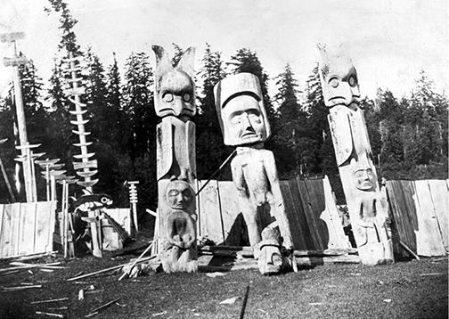
“Indians,” no matter what their status within their own hierarchies, were seldom welcome in “respectable” settler society at this time. As younger settlers replaced older ones, ignorance of Indigenous culture increased and the gap between settlers and Indigenous people grew. By 1900 few whites other than missionaries, and anthropologists such as Franz Boas, had any acquaintance with Indigenous languages. Indigenous people and newcomers had previously shared a coastal lingua franca known as Chinook. Although it lingered longer on the western shore, Chinook progressively fell into disuse on most parts of the Strait. Cole Harris suggested in Resettlement that BC around this time had essentially no past, just a present and a future—and both belonged to the newcomers. It was reminiscent of George Orwell’s Nineteen Eighty-Four: “Who controls the past controls the future: who controls the present controls the past.” Along with many place names, the Indigenous past and its stories, so deeply rooted in local places (see photograph here), had been written out of the settler narrative.
The idea that the Strait’s Indigenous people might be disappearing was widespread and reflected a growing belief in social Darwinism: that only the fittest survived. The corollary, in settlers’ minds, was that if Indigenous people were in fact disappearing, then taking their land and resources before someone else did was a prudent move in those times of freewheeling speculation. This perception conveniently justified the settlers’ voracious pre-emption of lands around the sea. It also revealed a lack of understanding about Indigenous people’s mobility and the nature of the social ties that linked them to extended family groups more than to single places. As more and more Indigenous people died, many survivors moved to other settlements to be closer to their relatives. And individuals who moved frequently, as Indigenous people often did, might elude the records of federal Indian agents altogether, thereby losing their claim to membership in a recognised band or to land on a fixed reserve. This was another, accidental way of “disappearing.”
The Strait’s Indigenous people, however, would not fully disappear. By 1900, smallpox still broke out occasionally, but there was now widespread inoculation and growing resistance to the disease. Encouraged by progressive leaders such as Billy Assu at Cape Mudge and mission schools, more Indigenous children were learning to read and write English. Authorities gave them Christian names that could be more easily pronounced by settlers.
Reserves, agents, potlatches & federal-provincial disputes
The Strait’s beleaguered Indigenous population was subject to a growing web of government controls. The federal Indian Act of 1876 had aimed to, among other things, suppress Indigenous cultures. An 1885 amendment to this act outlawed their traditional spiritual ceremonies and dances. Yet another amendment before World War I required all “status Indians” to obtain permission before appearing in traditional costumes in any dance, exhibition or pageant. While colonial power was mostly applied peacefully, threats of violent sanction remained a potent tool of persuasion. Michael Manson, the settler trader and provincial politician on the northern Strait, told of exercising authority over the Cape Mudge people in the late nineteenth century. Manson had met with resistance when he visited their reserve in his capacity as the local Justice of the Peace to investigate a suspicious drowning. He told community leaders: “[I]f they did not obey me in everything very dire punishment would be dealt out to them, the war vessels would be sent to blow up and burn their villages, the leaders of the tribe would be hanged and the Chief and all his family would be forever barred from being elected or holding the position of Chief of the tribe.”28 Unsurprisingly, Manson’s threat worked.
No single arm of settler government had full responsibility for Indigenous people, and no single perception of them prevailed within settler society. As a result, the settlers’ new system for “governing Indians” was complicated and full of baffling contradictions from an Indigenous perspective. Victoria controlled their land, while Ottawa was responsible for their bodies and churches watched over their souls. Victoria ruled the forests while Ottawa controlled the Strait’s sea life. The federal Department of Indian Affairs was learning to take care of its new charges as the resource rush gathered steam. Federal Indian agents were responsible for keeping records of Indigenous people, though some felt the province ought to begin recording the births, deaths and marriages of “their Indians,” as they did with settlers.
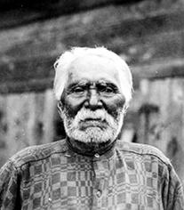
Indians came to be defined as “irresponsible children” under settler law (see photograph here), and the province was adamant that the kids should remain wards of the “federal crown.” Federally administered Indian reserves, meanwhile, contributed to growing separation between the Strait’s Indigenous and settler populations and seemed to be linked with Indigenous people’s poverty. The Royal Commission on Indian Affairs, launched in 1913, recognised that the tiny size of the Strait’s reserves might be contributing to the ongoing decline of Indigenous populations, while the province and many towns endeavoured to decrease their size still more.
Although James Douglas and G.M. Sproat had determined the boundaries of many early Indian reserves, Peter O’Reilly, who succeeded Sproat as Indian reserve commissioner, laid out the greatest number. He was not as preoccupied with Indigenous people’s concerns as Sproat or Douglas had been, and the boundaries of the reserves O’Reilly laid out in the 1880s and 1890s often resembled the new borders being drawn across Africa in those years—straight lines that reflected very little understanding of the societies they affected. Historian Robin Fisher has suggested that O’Reilly may have been appointed because of his lack of concern for Indigenous people. Often travelling the Strait on a Department of Marine and Fisheries steamer, he was usually impervious to Indigenous people’s complaints about his decisions. Whereas settlers around the Strait were excited by the prospect of the railway’s arrival during O’Reilly’s early years as commissioner because they felt it would boost land prices, Indigenous people increasingly feared losing what they had. They frequently sought clarification about their rights to traditional territories. Perhaps unsurprisingly, settlers could usually count on O’Reilly’s sympathetic ear, while he often concluded that Indigenous people were failing to effectively “use” or “occupy” land sought by settlers.
Federally appointed Indian agents governed most aspects of reserve life, and they played a host of roles that had earlier been carried out by traditional Indigenous authorities. Agents dispensed justice, settled disputes and controlled public nuisances. They cooperated with clergy to suppress potlatches, alcohol abuse and prostitution, and they made sure that Indigenous labourers showed up when and where they were needed. Indian agents were also expected to help Indigenous people improve their farming and fishing and, in order to avoid the “unnecessary” cost of formal land surveys, they helped their charges decide how to informally subdivide their reserves among themselves. Furthermore, agents were expected to counsel their charges to avoid “intruding or trespassing upon the lands, fisheries, etc. of other people or Indians [note the distinction].” And agents “ensured law and order” and dealt with troublesome or drunken Indians by keeping them “on the reserve.”
The potlatch—a traditional ceremony in which individuals made conspicuous displays of their wealth by giving much of it away to other community members—was a thorny issue. Churches longed to claim Indigenous souls, and the biggest barrier, they reasoned, was Indigenous people’s traditional belief system. This belief system was most clearly manifested in the increasingly elaborate potlatch ceremonies that proliferated around the sea in these decades, despite their legal prohibition after 1885. Missionaries, and some Christianised Indigenous people, were determined that settler law must eliminate this “heathenish custom in vogue among the Indians.” The potlatch, they said, made it impossible for these people to “acquire property or become industrious with any good results.” Men were forcing “daughters and wives to go into prostitution to earn the money for it.”29 Like earlier violence between Indigenous groups, the excesses of the potlatch seemed to confirm the need for a corrective intervention by settler society. What many could not see—though the more observant missionaries certainly could—was that the potlatch was central to Indigenous people’s traditional “prestige economy” (see photograph here). Government efforts to suppress the potlatch mounted after the 1880s, but it was not easily eradicated.
Land hunger, the province & local governments
Pre-emptions continued through the 1880s and into the 1890s, stimulated by the railroad’s arrival, distant markets for the Strait’s resources and growing local markets for farm produce and real estate. Settlers claimed land where it was still available early in the resource rush, mostly on the less hospitable Mainland shore. Small farms and orchards also appeared on the shores and islands of Howe Sound. For example, a decommissioned Royal Engineer had pre-empted over 100 hectares at Sechelt in 1869 and many followed him, claiming land from Howe Sound to Desolation Sound.
While Victoria was generally unsympathetic to Indigenous concerns, many local governments were openly hostile. Indigenous people and their reserves were usually a nuisance to rapidly growing settlements, to be gotten rid of or at least hidden away. Reserve land was unsightly, untaxable, unavailable and increasingly in the way of urban development. A growing list of towns and cities expressed their frustration with Indian neighbours who were occupying valuable land and thwarting the ambitions of new settlements to grow and prosper. The new Corporation of Surrey was incensed by federal government plans to establish a reserve at Semiahmoo Bay in the late 1880s. Even Peter O’Reilly—usually the settlers’ ally—pointed out that Indigenous people had clearly been occupying this place for a long time. Captain Christian Mayers further confirmed seeing them at this site since 1858. However, Surrey countered that this was “about the best place in BC for a sea side summer resort,” and these weren’t even “BC Indians” but a crowd of “American Indians” who went there for “drunken orgies.”
If granted this reserve, claimed officials in Surrey, the First Nations people would be “a source of danger and moral blight in our midst.” In turn, Indian Affairs cited a number of “expert witnesses,” including Bishop Durieu, who confirmed that these really were “BC Indians.” But Surrey was not prepared to lose this valuable waterfront without a fight. Even if these weren’t American Indians, they argued, they came to this shore for only a few weeks a year to fish. Presumably settlers would stay longer at their beachside cottages. Besides, these Indians had cultivated only eight of the 125 hectares they were claiming. Finally, once the reserve looked inevitable, Surrey tried to have it restricted to no more than 20 hectares. This was necessary, it said, to reduce harm to Surrey, which already had 117 applications to purchase two-acre (0.8 hectare) lots for summer residences on the bay. The Semiahmoo reserve was eventually established in 1887 on 130 hectares of land; much of it would eventually be leased to the Municipality of Surrey for recreational purposes.
Other reserve land in or near towns was becoming the target of vigorous efforts to wrest it from Indigenous owners. The towns of Comox, Qualicum, Ladysmith and Duncan all launched their own campaigns to remove or diminish local reserves with very similar arguments: Indigenous people were failing to “develop” land that had been “given” to them and so did not deserve to keep it. Most settlers felt that “Indians who did not use land set aside for them in ways consistent with newcomers’ assumptions had no right to retain it.”30 Many towns saw their development as being handicapped by their inability to develop this valuable land, especially reserve land along the shore or riverbanks, which much of it was.
Early in the new century, Ottawa gave in to growing national pressure and amended the Indian Act to make it legal for towns with at least 8,000 inhabitants to seize adjacent reserve lands “in the interest” of the public and Indigenous people, even if the latter didn’t consent. Municipalities and firms could also expropriate portions of reserves, without permission, where land was needed to build roads, railways or other infrastructure. By 1913, towns around the Strait were in a feeding frenzy, goaded on by a heady real-estate boom and inspired by the City of Victoria, which had managed to displace Indigenous people from the Songhees Reserve on its inner harbour.
Squamish people were similarly “unsettled” from their reserve at Kitsilano Point, or Snauq, where Indigenous people had been fishing nearby sandbars (later christened Granville Island) for many generations. For the new City of Vancouver, the reserve was an eyesore near the increasingly popular English Bay beach, and officials felt many more economically valuable things could be done with land at the entrance to what was becoming an important industrial area on False Creek. In its haste to consummate the “unsettling” of Snauq, the province overstepped its legal mandate and bypassed federal authorities. The ensuing legal quagmire lasted for decades, and the Squamish retained control of much of the land they had been persuaded to vacate. A local paper described Victoria’s actions in the Snauq affair as “the greatest scandal in the history of the Provincial government of BC” and declared them “liable to a term in the penitentiary [if undertaken by]…an individual in the community.”31
Other instruments of colonial government
With the Strait firmly under settler control by the late nineteenth century, the same sort of expropriation that had taken place on land was also conducted on the water. Settlers claimed the sea as their own to exploit on as large a scale as they could manage, and fish quickly became a key export commodity (chapter 4). Yet salmon, herring and clams also remained indispensable food resources for Indigenous people. The DMF in Ottawa began on the water what the Indian Reserve Commission had begun on land, progressively stripping Indigenous people of control over resources that had sustained them for centuries. Commercial fishermen even fished waters theoretically reserved for Indigenous people, as the Royal Commission on Indian Affairs reported in 1916:
"With respect to small reserves described and constituted as “fishing stations” and covering streams from which the Indians from earliest days have been accustomed to obtain their fish food supply, it has been in numerous instances declared in evidence by the interested Indians that the purpose and utility to them of these reserves has been wholly or in large measure destroyed by the subsequent allowance of cannery seining licences by which such “fishing stations” have been blanketed and rendered of no use to the Indians.32
"
Indian commissioners Sproat and O’Reilly had assumed Indigenous people would maintain control of the salmon fishery. The DMF, on the other hand, never intended for settler industry to be denied this valuable resource. The industrial fishery needed Indigenous labour but did not want Indigenous competition. Lobbying to curtail traditional Indigenous fishing activities began almost from the outset of the settler fishery and intensified with the arrival of the railway. By that time, more than 6,000 commercial fishers were active on the Fraser, many new canneries had been built and the first evidence of overfishing was already visible. A poor Sockeye run in 1916 was blamed on First Nations “food fishing” and two years later, the DMF brought in the first regulation to govern Indigenous people’s fishing for food.
The new fishing rules were at least as hard on Indigenous people as the new land laws were. While settler fishers could set their nets at the mouths of salmon streams, Indigenous people might be arrested or fined for fishing in the wrong place or at the wrong time or using the wrong gear. The DMF placed limits on the types of fish Indigenous people might catch, requiring them to obtain permission to sell salmon, ostensibly because of a concern that First Nations fishers were the main cause of declining fish stocks. In many places, as concerns about fisheries depletion began to appear in the public record, so did accusations that Indigenous people were important contributors to the problem. The Royal Commission on Indian Affairs, which was launched in 1913, heard repeated warnings from settlers about First Nations’ “wasteful” use of salmon especially. But an Indian agent complained it was difficult to teach conservation to his wards in light of the “huge waste of salmon by the [settlers’] Fraser River canners.”33
Indigenous people increasingly worried about their access to food fish.34 When they were not fishing for the canneries, they could fish only for their families’ food and they had to ask Ottawa’s permission even for this “privilege.” And successive settler governments began to see traditional fishing practices as unacceptable. The Cowichan people, for example, struggled with Ottawa for years over their right to use their traditional weirs on the Cowichan River (see photograph here), which authorities deemed “a distinct violation of the law.” A deal was eventually struck limiting the Cowichan to three weirs. Then they were limited to using only dip nets, which they had not used much in the past. These regulations were put in place because settler sport fishermen, enamoured with the Strait’s Chinook and Coho salmon and Steelhead trout in particular, were growing alarmed by the “depredations” of Indigenous fishers. Controversy over the Cowichan weirs, for example, was stimulated partly by sport fishers protecting their favourite angling stream. Ironically, when Indigenous people raised their own conservation concerns, particularly about the growing export of Chum salmon to Japan, federal officials dismissed their concerns about depletion out of hand. The government ignored the fact that Chum—a species mostly of interest to the Japanese Canadian commercial fleet at this time—was an important source of food for Indigenous people. It conceded, however, that such Indigenous complaints were a sign that local First Nations people were becoming “somewhat more progressive,” less like “helpless children” and better able to “accept conditions as they exist today.”35
Fish were not the only traditional food source under siege. By 1914, Indigenous people on the southern Strait needed permits to hunt deer too. These permits were issued by the provincial game wardens, but only on the recommendation of an Indian agent and after consideration of an applicant’s age and family size. Even duly licensed, Indigenous hunters could take no more than four deer in total in a season and three of any single deer species, unless they obtained special permission from the game warden. The northern Strait was still classified as “unorganised districts” where First Nations hunters could kill more than four deer in a season, but only to feed their families. They were prohibited from selling the meat. Indigenous duck hunters were likewise circumscribed by new laws, though in 1914 the provincial game warden advised his agents to “be lenient” in enforcing the rules—except near the Strait’s largest towns—when it came to those duck species that “are not esteemed edible by white people.”36
Soon, the need for new transportation infrastructure was also used as a reason to remove land and resources from Indigenous hands. A federal government report summarised the “Indian land” around the sea that had been leased for other uses between 1871 and 1911. It was a long list: strips for moving logs to the shore or building railway and highway rights-of-way, land for developing urban and port infrastructure, marine space for storing log booms, and on and on. Indigenous communities were vulnerable to these demands because so many were located on shorelines (see photograph here), where the ports, railways and roads so critical for the growth of the settler economy all converged. The Dunsmuirs’ E&N Railway cut a 30-metre swath across the Esquimalt reserve, removing all the timber and houses that were in the way. Citing the Railway Act of 1879 and its later amendments, the company aimed to expropriate the entire Songhees reserve for its Victoria terminal and it eventually received part of it.
An 80-hectare Squamish reserve at the mouth of the Capilano River was reduced first by 1.4 hectares for a road right-of-way in 1912 and then by another 7.5 hectares for a railway in 1913. In 1917, the Harbour Commission had acquired rights to the reserve’s foreshore. The smaller Squamish reserve at Kitsilano Point was reduced by 4 hectares in 1886 and 1902, first for a CPR bridge across False Creek and then for a railway through the reserve (it was never built). The federal government’s Harbours Board also insisted, unsuccessfully, on its right to part of the reserve for new harbour and rail facilities. Then another 3.2 hectares of the Kitsilano Point reserve were taken to build the Burrard Street Bridge in 1930. Sometimes residents of these reserves received compensation; often they didn’t.
Settler demands for recreational space also removed Indigenous people from traditional territories. Semiahmoo Bay, discussed above, was just one case. By 1900, Vancouver’s new Parks Board had removed all Indigenous homes except one from a former village site, Whoi-Whoi, on Burrard Inlet in Stanley Park. Elsewhere around the sea, Indigenous people began to lease their reserve land on beaches so that settlers could build summer cottages. Perhaps they calculated that it was better to offer this land on long-term leases than to risk losing it because it was “not being used.”
The success of a reserve, however, was often judged by how well people were farming it. The Royal Commission heard testimony praising Indige-nous people in Saanich who “display evidence of considerable intelligent cultivation.”37 At Nanoose and Comox, the Indigenous people were criticised for leaving so much land uncultivated, suggesting that perhaps they had more land than they needed. Failure to farm more land or properly manage land they did farm was widely seen as an indictment of a dissolute lifestyle. Yet without an agricultural tradition to draw on and with limited lands of uneven quality, they required much technical advice to become “good farmers.” And, as “Indians,” they weren’t able to get the technical support that Ottawa and Victoria provided to settler farmers.
Indigenous people’s only source of technical advice was their Indian agent, who had many other duties. Despite difficulties adapting to farming, Indigenous people on some reserves before World War I began to claim the right to 64 hectares each. An Indian agent in the Cowichan Agency explained to the Royal Commission that such demands were “purely political.” Indigenous people, he said, had been coached by “dangerous radicals” and were “only asking this because white men are allowed to pre-empt a hundred and sixty acres [64 hectares] of land.”38 It seemed obvious to authorities that Indigenous people could never make good use of such large tracts of land for farming even if they were still available, which they weren’t.
From Riel and railways to the McKenna-McBride Commission
Indigenous people were not the only ones dissatisfied with colonial dispossession around the Strait before World War I. Many settlers, backed by their provincial and municipal governments, felt First Nations still had too much land. As was common among colonial governments around the world at the time, the Royal Commission on Indian Affairs, or the McKenna-McBride Commission, was launched in 1913 to “settle the land question once and for all.” Here, as in most other colonial territories, this commission was another opportunity to break earlier promises to Indigenous people. Premier James Dunsmuir, son of coal magnate Robert Dunsmuir, had approached Ottawa as early as 1901 calling for “better terms” for BC. Many BC reserves, he said, needed to be reduced because too much valuable agricultural land was held by too few Indigenous people. The Department of Indian Affairs, having spent many years negotiating these reserves, was slow to respond. When Premier Richard McBride pressed a more forceful claim in 1912, the federal government acquiesced and launched a joint federal-provincial commission the following year. The McKenna-McBride Commission was tasked with “equitably adjusting” reserve boundaries “one last time.” Full and unfettered authority over reserves would then be handed to the federal government.
The Royal Commission allowed settlers and Indigenous people to plead their cases (see photographs here). Complaints from the Strait’s rapidly growing towns have been described earlier. The commissioners also received eloquent testimony from Indigenous participants, though they seldom responded positively to them. Chief Julian from Cortes Island told them: “If we do not kill deer out of season we have nothing to eat.”39 In the Cowichan, Chief Que-Och-Qult complained: “The cost of living…has greatly increased while at the same time the Indian’s facilities for earning his living had been greatly handicapped by the fishing and game laws of the whites and the reduction of the Indians’ natural food by the demands of the white market.” Indian Dick reported: “Everything has been taken from us and we have nothing. They have taken our grub and we have nothing at all. God gave us fish and animals so that we might live on the country and they have taken all these things away from us.” Chief Joe Eukahalt remarked: “The white men are making laws that are getting our people into trouble…They cannot get their grub anywhere without being guilty of violating some law.”40
Such moving statements from Indigenous leaders revealed the enormous changes to the lives of their people that had taken place since the onset of Eurasian resettlement of the Strait only a couple of generations earlier. From their perspective, the inland sea and its rich littoral had been theirs from time immemorial. Now this place and its resources were mostly off-limits to them and would be shared only very sparingly, according to the arcane rules and norms of the newcomers.
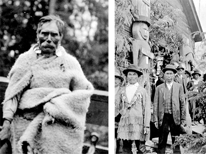
Stagnation but not disappearance during the interwar years
Indigenous people lived mostly outside settler society, though they remained a valuable industrial proletariat around BC’s inland sea during the interwar years. The settlers’ Strait was now well integrated into global socio-economic networks but its people were three times wounded between 1914 and 1945: by a savage war in Europe, a decade-long severe economic downturn after 1929, and a truly global conflagration. Not surprisingly, this turbulent period did not see much opening of settlers’ minds to the oppressed Indigenous minority in their midst. It did, however, see an end to more than a century of declining Indigenous populations.
A vanishing culture
By 1921, Indigenous people had not disappeared, as a succession of provincial and municipal governments had hoped they might. They now accounted for only 4 percent of British Columbia’s population, however, and probably about the same around the Strait, which remained the province’s centre of gravity. The Indigenous population finally stopped shrinking in the 1920s, though physical traces of their culture (see photographs here and here) were still vanishing from the landscape. In Sunshine Coast, publisher Howard White remembered the Pender Harbour settlement of his childhood, where “only a few traces remained of the teeming, robust Salish city.” At nearby Sakinaw Lake, only vague traces remained of the Sechelt people’s intricate fish traps, which early in the twentieth century were described as “a masterpiece of stone age engineering.” By mid-century they had virtually disappeared, obliterated by loggers. Huge forest fires on the Malaspina Peninsula in 1918, and another twenty years later between Comox and Campbell River, destroyed many traces of the Indigenous presence in those areas. In Stanley Park, an iconic symbol of natural splendour on the doorstep of the Strait’s dominant city, the final “Indian squatters” were evicted and their houses razed in the early 1940s. In 1943, the Vancouver Parks Board briefly considered constructing an “Indian Museum” on the site of the Indigenous settlement called Whoi-Whoi in Stanley Park. Instead, a memorial was erected to the lumber industry.
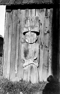
Summer cruiser Francis John Barrow and, a decade later, writer Frederick Marsh both noted a growing scarcity of Indian artifacts. Barrow was in the habit of searching Indigenous middens he found while looking for pictographs around the northern Strait and beyond. By the late 1930s, he complained regularly of finding promising midden sites already emptied of artifacts. Marsh reported a few years later that on the southern islands, “Indian relics” that were once common, such as “flint spearheads, chisels, pestles and stuff like that, all over,”41 had become hard to find. Many of the clamshell middens, where artifacts could most easily be found, were disappearing under houses and streets.
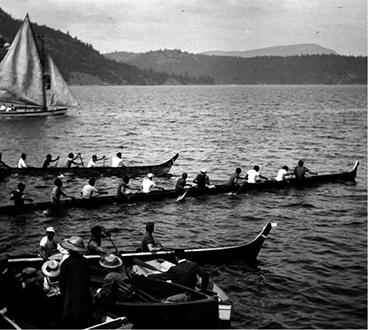
Attempts to eradicate Indigenous culture paralleled the disappearance of its physical remains. Suppression of the potlatch escalated in the new century. The Cape Mudge people had to hand over their potlatching regalia in the 1920s. Masks and costumes, deemed sinful vestiges of a pagan past, were surrendered to federal authorities to be destroyed. Instead, they were transferred to the National Museum in Ottawa. Despite the ban and missionaries’ pressure to enforce it, potlatch ceremonies continued around the Strait in the interwar years. Settlers who witnessed them were awed by the powerful rituals. In Adventures in Solitude, Grant Lawrence recounted the story of Alice Bloom, a settler on Okeover Inlet off Desolation Sound in the interwar years. Bloom “recalled with great fondness that on certain nights each winter, she and her family would secretly watch the Natives dance around a raging bonfire on the shores of Kahkaykay during their potlatch celebrations, their singing filling the night.”
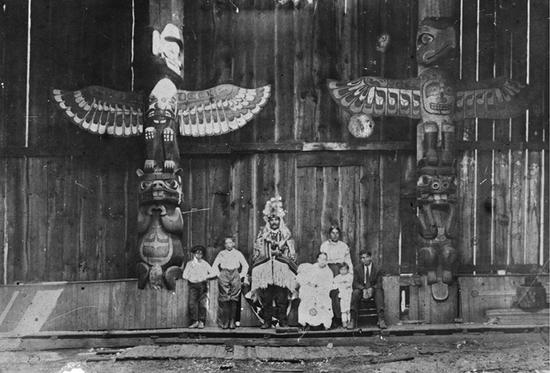
Frederick Marsh recounted a similar story from a Mrs. Forbes about a potlatch she witnessed in the same period at Penelakut village: “Around a fire built, Indian style, in the centre of a long community lodge with a hole in the roof to let out the smoke, thirty performers danced with increasing frenzy before several hundred Indian spectators. A handful of privileged whites…looked on from a high gallery…The rhythmic beating of tom-toms caused dancers and spectators to sway in unison. The atmosphere, blue with smoke and ruddy in the flickering firelight, seemed to pulse with highly charged emotion…Their men…danced almost to exhaustion.”42
Indigenous people were expected to “assimilate” rather than pursue these traditional cultural practices (see photograph here), let alone pursue claims to traditional lands that Victoria and Ottawa now considered pointless. Duncan Campbell Scott, the head of Indian Affairs through much of this period, described a “sentiment for the extinguishment of the Legal Indian” and expressed his own goal of “getting rid of the Indian problem” by ensuring all Indigenous people were fully “absorbed into the body politic.”43 Concerned that Indigenous people were not shedding their traditional culture fast enough, successive governments began forcing Indigenous children into residential schools. Legislation passed in 1920 obliged parents, under threat of imprisonment, to send children who were between five and fifteen years of age to residential schools to learn “practical skills.” Indian agents and RCMP officers began rounding up the children and sending them to schools in places like Sechelt, Mission and Kamloops. There, children were often abused and were forbidden to speak their parents’ languages. Many Indigenous people are still experiencing trauma related to the residential school experience today.

Continued land hunger
The intense land hunger that had consumed so much Indigenous traditional territory abated somewhat in the interwar period, but even if settlers no longer sought Indigenous land for farming, towns, railways and industries still did. The Squamish and Musqueam reserves, from the mouth of the Fraser to the head of Howe Sound, were frequent targets. At the dawn of World War I, the City of North Vancouver had joined forces with adjoining North and West Vancouver district governments in an unsuccessful effort to acquire 300 hectares of Squamish land adjacent to their settlements.
In the early 1920s, perhaps inspired by the Pacific Great Eastern Railway’s (PGE) expropriation of a portion of the Squamish reserve at the north end of Howe Sound and anxious to expand industrial activities adjacent to its own new PGE terminal, the City of North Vancouver returned to its pursuit of the Squamish band’s land. The municipal government suggested its Indigenous neighbours should be removed to the other Squamish lands at the head of Howe Sound. The Squamish leadership successfully resisted: “What would we do up Howe Sound?” they asked.44 They were no longer fishers and had never farmed, and their work at the time took place mostly at Burrard Inlet’s docks and mills. Railways could still expropriate with impunity, but Indigenous people were better at resisting municipal encroachments. The Squamish, by the mid-1920s, were organised and skilful in defending their interests, though the many resolutions they passed still had to be “subject to the approval of the Department of Indian Affairs.” By the end of World War II, they were major owners of industrial land in North Vancouver.
Governance
The Royal Commission on Indian Affairs dragged on through the early years of World War I with the goal of reaching a final agreement on land allocation for Indian reserves throughout BC. The province contested the commissioners’ recommendations, still finding the reserves too large, while Indigenous groups continued to see them as too small. This wrangling went on through most of the interwar period. Victoria and Ottawa finally agreed on reserve boundaries, and the official transfer of reserve land to the federal government, in 1938. In the province as a whole, they added about twice as much land (350 square kilometres) to reserves as they removed (190 square kilometres). The overall value of the land they removed from reserves, however, was roughly six times greater than the value of the land that was added.
Around the Strait, slight reductions were made to already small reserves. Along the western shore, total reserve land was reduced from 4.05 to 4.04 acres per person and on the Mainland shore from 6.66 to 6.60 acres per person. Ottawa and Victoria shared the money generated by the sale of these expropriated lands, with the federal share going, as usual, into Indian Affairs trust funds. Both governments expected this would be the final word on Indigenous land allocation. After hearing a land claims presentation by the Allied Tribes of BC, the federal government had again amended the Indian Act in 1927. From then until 1952, it was simply illegal for Indigenous people to raise funds to pursue land claims, except in the unlikely event that they obtained permission to do so from the Department of Indian Affairs.
By the 1920s, the federal fisheries department had become the resource manager for the industrial fishery. The canneries had secured exclusive control over almost all commercial salmon fishing by this time, and fisheries regulations enhanced Indigenous people’s opportunities for work in the industry. Boats owned by Salish and Kwakwaka’wakw speakers became a substantial component of the commercial fleet on the Strait, while Indigenous women remained an important part of the canneries’ labour force. Indigenous people’s right to fish for their own food, on the other hand, came under further assault. Beleaguered Fraser River Sockeye runs, though much reduced by the landslide at Hells Gate in the Fraser Canyon in 1913, were showing modest signs of recovery by the late 1920s. As in earlier years, however, Indigenous people continued to be singled out as a threat to fishery conservation efforts. The chief federal fisheries inspector for BC declared in 1929 that Indigenous people no longer needed a food fishery. And early in the 1930s canners tried, in vain, to demonstrate that the food fishery was superfluous by supplying reserves with crates of canned pilchard and Chum salmon.
The damage being done to sport fishing by Indigenous fisheries was a public concern. Saanich Inlet had become a popular sport fishing site, with a growing collection of summer cottages on its shores. Indigenous people on the inlet, earlier guaranteed the right to fish there under their Douglas treaties, were first prohibited from using nets at that site, then banned from fishing on the inlet altogether. A similar proscription of First Nations food fishing in favour of the sport fishery eliminated their right to take fish from North Vancouver’s Capilano River with anything other than an angler’s hook and line.
Indigenous communities around the Strait also struggled to retain access to traditional clam beds. For example, when the Comox lost control over rich clam beds surrounding Tree (Sandy) Island, a tiny archipelago at the head of Baynes Sound, they appealed to the government to get them back. Clams were an important traditional food source for the Comox, and the islands had been pre-empted by a settler and then sold to the British Lords of the Admiralty at the end of the nineteenth century. They were later transferred to the Canadian navy, which used them for target practice in the 1930s. Denman Island settlers had also begun digging clams on Tree Island, while the fish-canning conglomerate BC Packers claimed the beds too, though it had stopped working them by the late 1930s. The Comox tried to broker a complex bargain in which they guaranteed the navy access to nearby Goose Spit in perpetuity in exchange for renewed Indigenous control over Tree Island’s shellfish-rich foreshore. Negotiations ensued between Ottawa and Victoria, and while Indian Affairs was able to secure the barren islets, it could not convince the province to surrender the foreshore around them—which was all the Comox people really wanted.
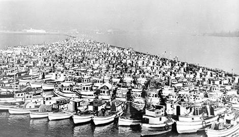
As they had with their claims to land—until such actions became illegal—Indigenous people also protested the erosion of their fishing rights. And associations of Indigenous fishers became surrogate political organisations in this period, since the Indian Act had otherwise muffled all resistance. The Native Brotherhood of BC, founded in the early 1930s, became the principal voice for Indigenous fishermen on the coast, but its members’ efforts to secure control over fishing grounds adjacent to their reserves—as had been envisioned when these reserves were originally demarcated—were unsuccessful. In the late 1930s, Andrew Paull, Secretary of the Progressive Native Tribes of BC, wrote to the Superintendent General of Indian Affairs in Ottawa to ask for exclusive use of the waters off Cape Mudge for the people of that reserve. He explained:
"Waters in front of the Cape Mudge reserve are the spawning grounds of the Codfish but it will soon be depleted as Japanese fish in front of this reserve for ten months of the year…The opposite waters in this channel is reserved for sporting fishermen and the Indians cannot fish there commercially. On their side of the channel in front of their reserve, it is overrun with Japs fishing for Codfish, and during the salmon fishing season…gradually and by degrees the native Indian is squeezed out of the only means he has in these parts of earning a livelihood.45
"
The Minister of Fisheries refused Paull’s request, however, citing his ministry’s need to protect the “public right to fisheries,” even those adjacent to reserves. The minister declared, “The granting of fishing rights or privileges to one class of fishermen that would not be available to others would not be feasible.”46 It was a bold argument in light of the long list of other rights and privileges that Indigenous people were denied at the time.
Paull’s claim of Japanese Canadian fishermen’s depredations at Cape Mudge was a familiar refrain by the 1930s. Decades earlier, such complaints had figured prominently in testimony to the McKenna-McBride Commission. Indigenous people’s perception of the “Japanese threat” to the Strait’s natural bounty was widely shared in the white fishing community, and these fishers may have been an easier target for Indigenous discontent than the white bosses of the industrial fisheries. The sudden removal of Japanese Canadians from the West Coast in 1942 (see photograph here) helped make World War II a time of “unprecedented gains” for Indigenous commercial fishers. Many boats were suddenly available, the war effort needed fish, and it needed labour in the boats and canneries.
Impacts of farming, forestry & transportation
By the interwar years, the idea of the Strait being converted into a version of the British seaside had receded, and much of the land that had been cleared for farming or logging was returning to forest. Meanwhile, smaller tracts of (often the best) forest land disappeared under new towns and cities, so that BC was the least agricultural province in the Dominion by the 1920s. Writing in Maclean’s magazine in the mid-1930s, Comox Valley naturalist Hamilton Mack Laing noted the dwindling popularity of “stump ranching” around the sea. He predicted that much of the land that settlers had worked so hard to clear was destined to become golf courses and drive-in movie areas within a generation. Agriculture on the southern islands began to stagnate due to their growing isolation from the ever more highway-based economy on the Mainland and Vancouver Island. The thriving market gardens of Japanese Canadians on these southern islands were an important exception, but these did not survive World War II.
Ultimately, the myth of the yeoman farmer by the sea had helped legitimise the rapid dispossession of the Strait’s Indigenous people, yet much of that land had never been farmed at all, only logged and then abandoned. This story of “improvement” survived at Indian Affairs, however, as the department’s forestry directives stipulated: “Lumbering operations on a Reserve must, as far as possible, be co-ordinated with the clearing and preparation of the land for cultivation, and the principal aim to bear in mind should be to restrict such lumbering to certain prescribed areas, so that the cutting of timber under permit shall constitute the initial step toward agricultural improvement.”47
Ottawa clearly had little understanding of either farming or lumbering around the Strait. Yet, as the directive suggests, the department carefully governed logging by Indigenous people on their reserves. All timber was deemed common property, and any timber sold to interests off the reserve had to be approved by a majority of adult male members of the band. Any band member who wanted to harvest timber had to first obtain a recommendation from the band’s governing council and then permission from the Department of Indian Affairs. He or she could then cut and sell reserve timber under the local Indian agent’s supervision, but “in no instance should timber be removed from a reserve before the dues [payable to the Department of Indian Affairs] have been collected.”48 Finally, Indian agents were to warn their wards “of the fallacy of regarding their timber as a perpetual source of income. It is far easier to exercise a judicious conservation of timber resources today than to face the expensive alternative of re-forestation in the future.”49 Once again, federal pronouncements were remarkably out of touch with the realities of the settlers’ Strait, where systematic overharvesting of timber had become the norm (chapter 3).
Just as they had before the war, a number of reserves, perhaps making virtue of necessity, continued to earn significant income from leasing their foreshore to industrial users, especially for log booms. Although the foreshore in front of reserves had often been contested in the past, with First Nations repeatedly claiming control over the beaches in front of their allotted land, Indigenous authority was increasingly questioned during the interwar years, especially by owners of houseboats and log booms. Eventually the province gained control over beaches in front of reserves, except where Indigenous right to these beaches had been explicitly mentioned when the reserve was established, which it seldom had. In some cases, the province required Indian Affairs to repay rent it had previously charged forestry companies to store their booms off reserves. Reserves lost their foreshore rights to Ottawa in harbours that were under its control. The newly constituted “public harbour” on Burrard Inlet, for example, asserted its own control over the foreshore and considerable stretches of shoreline previously controlled by the Squamish people.
Expropriation of reserve lands for transportation infrastructure also continued through the interwar period. After World War I, the new highway system that rapidly developed around the Strait diminished a number of reserves. Provincial highway engineers were confident of their rights and eager to get on with their projects, as the Malahat people discovered in the mid-1920s. They were given no advance warning before piledrivers and carpenters showed up to construct a ferry terminal on their Mill Bay reserve. A few days earlier, the provincial engineer had sent a letter to the Department of Indian Affairs stating simply that the province was about to build a landing for a ferry service that would traverse Saanich Inlet (see photograph here) and that the chosen site lay within the boundaries of the reserve. “It is necessary,” he wrote, “that construction commence immediately which does not allow time for formal notification but proper plans and descriptions will be filed in due course.”50
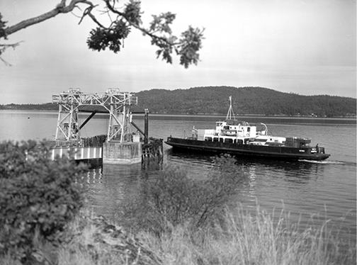
It turned out that people on the Malahat reserve were “bitterly opposed” to this ferry terminal. The bureaucrats of Indian Affairs had no choice but to acquiesce, however, because except for a few federally controlled harbours, the province was now deemed to “possess the foreshore.” Indigenous people’s only rights were to “access and ingress”—to come and go across the beach in front of their reserve. Indian Affairs officials did point out that it was, nonetheless, unfortunate that the ferry slip had been located over their cemetery, from which remains should be exhumed and reinterred elsewhere at the expense of the province. Unfortunate as well that the new road leading to the ferry dock had been built “through practically the only good piece of land on the reserve where the Indian village is situated and will disturb a considerable amount of Indian improvements.” It also threatened to foul the reserve’s water supply.51
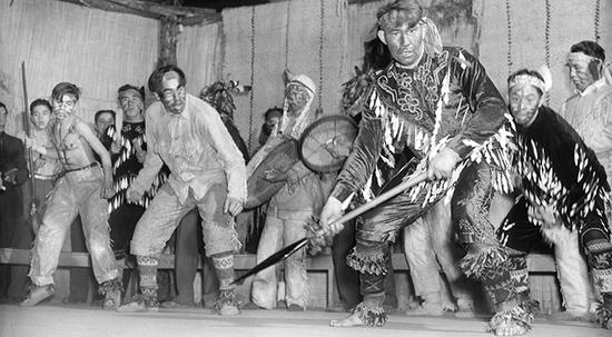
The same, but different
Settler assaults on Indigenous people’s claims to space and resources around the Strait continued through the interwar period, but the ability of Indigenous communities to resist was growing. They salvaged vestiges of their cultural heritage (see photograph here). They learned the intricacies of settler laws and governance and how to work within them. The people at Cape Mudge had asserted themselves in negotiations with local cannery owners and loggers, and Chief Billy Assu had ensured that his people received more equitable working conditions. He encouraged them not to assimilate but to adapt in order to benefit from the settlers’ ways without losing their identity. At Cape Mudge and elsewhere around the sea, Indigenous leaders now knew that their dispossession had contravened the settlers’ own laws.
Some settlers, too, began to recognise that the colonial adventure may not have claimed just “idle lands” and “unused resources” but also the birthrights of others. Among the men returning from war in Europe and Asia were those who could see the injustice faced by their Indigenous comrades, who had also fought and died for Canada but still could not vote in their own country.
The beginnings of decolonisation after World War II
The decades after 1945 were a period of decolonisation around the world. World War II had demonstrated some possible outcomes of theories of racial superiority. The horrors of this war, and then independence movements across Asia and Africa, stirred growing consciousness of settler societies’ unjust treatment of Indigenous peoples. Many Indigenous communities around the Strait had become deeply dysfunctional after more than a century of disease, dispossession, marginalisation, racism and attempted cultural genocide. Yet they were also remarkably resilient: they had refused to meet settler society’s expectation of their disappearance and remained determined to reclaim their heritage.
Reappearance
W.A.C. Bennett, the provincial leader through the 1950s and ’60s, reflected the attitudes that still prevailed when in 1958 he celebrated the history of BC’s first century as “the story of development, of the building of a…homogeneous [emphasis added] province; of a God fearing pioneer people dedicated to progress, strengthened by their contest with a great land at first reluctant to yield its full resources.”52 Before the era of federally financed multiculturalism, which began in the 1970s, there was no obvious place for Indigenous people in Bennett’s vision of a homogeneous settler society hewing resources from a reluctant land. Even naturalists on the inland sea, such as Hamilton Mack Laing, whose perspectives were often trenchantly at odds with Bennett’s and who had some appreciation of Indigenous heritage, still tended to celebrate mostly the resplendent nature of the place rather than Indigenous people’s ties to this nature. Early in the post-war era, many people around the inland sea were more likely to associate Indigenous people with beer parlours than with nature.
Although Indigenous people were still often disregarded—particularly by the provincial government and industry—a growing number of writers, scientists and academics were stimulating greater public awareness of Indigenous culture and concerns. James Matthews, the first archivist at the Vancouver Museum, interviewed Squamish people through the 1930s, and in 1948 the museum issued the result: a quirky collection of hand-typed pages and original photographs listing and discussing Indigenous place names on Burrard Inlet and Howe Sound that had been “certified correct” by the Squamish Indian Council. It was a remarkable act of recognition in a city that until then had mostly erased traces of Indigenous occupation. Matthews’s work with the Squamish revealed deeper human bonds with places now overlaid with recently acquired settler names.
West Point Grey, which was filling with settler homes and seaside parks, had been called Ulksen. Lumberman’s Arch, on the Burrard Inlet shore of Stanley Park, had been erected on the site of the large village called Whoi-Whoi (or Xway xway), named for the traditional masked dances that had been performed there. Caulfeild in West Vancouver had been Stuck-Ale, a name describing the foul smell of gas that rises naturally to the surface there. Horseshoe Bay had been called Cha-Hay, a name evoking the sound made by millions of herring moving across the water as they spawned on the bay. Homer Barnett, Wayne Suttles and other anthropologists devoted their careers to studying Coast Salish–speaking people. Their work began to seep into the public discourse and inspired a new generation of researchers. Like Matthews’s work and a growing body of archaeological evidence, these studies raised awareness among the settler population of complex, long-standing human relationships with the rest of nature on the Strait.
By the 1960s, writers and journalists such as Roderick Haig-Brown and Imbert Orchard were presenting the public with positive images of Indigenous people and their struggles. Haig-Brown was effusive in his praise for the Cape Mudge people’s “very great chief” Billy Assu. Haig-Brown, who lived in nearby Campbell River, had known Assu for decades and their families would later be linked by marriage. Orchard, in his extensive oral history of the Strait, explained to CBC listeners in the early 1960s: “Often the Indian child in a residential school was forbidden to use his native language or sing his own songs. As a result, a culture was destroyed, and an alien culture superimposed, without any regard to the psychological effects.”53 This story of Indigenous people’s trauma had seldom been heard in settler society at the time.
The threats that local writers and artists depicted around the sea were now likely to be loggers, developers and others promoting rampant urban growth. Poet Earle Birney and Haig-Brown were more inclined to portray past Indigenous cultures on the sea as “ecological Indians”54 who had achieved a harmony between humans and nature and whose secret had been lost to industrial society. Literary critic Allan Pritchard suggested that Haig-Brown and others may have tried to establish a tie with Indigenous people out of a desire for a more legitimate claim to belonging in their adopted land. What their work did was highlight the reality of Indigenous people’s dispossession, a theme explored in books such as Jack Hodgins’s Resurrection of Joseph Bourne.
By the 1970s, the province’s interpretation of “local heritage” that needed pre-serving around the sea was a hodgepodge of familiar settler vestiges—early post offices, churches, stores and cemeteries—mixed with mysterious petroglyphs (rock carvings) from the Strait’s Indigenous world (see photograph here). A brochure celebrating the Diamond Jubilee of Saanich District in 1965 declared that South Saanich had been purchased on February 6, 1852, through an agreement signed by local Indigenous people and that North Saanich was purchased from them five days later. Few other settler communities on the Strait could hark back to such agreements with Indigenous people, and many would begin to regret such deficiencies. Around this time, Indigenous people began to reappear in official representations of the sea’s past.
By the late 1970s BC’s roadside information panels, which were erected at scenic lookout spots along the highways, described “Indian woodworking tools of the Northwest Coast” and “Food and cooking of the Northwest Coast Indians.”55 The provincial archaeologist expressed concern about the degradation of “archaeological resources” on many of the islands in the Strait. Less than 10 percent of 800 archaeological sites on the islands were still intact, he reported, and many had been disturbed during the century of resettlement. “The worst offender” had been “construction of permanent and summer residences…[while] marine facilities such as ferry landings, wharves, marinas and the like have also taken a great toll.”56
Indigenous people themselves were increasingly involved in efforts to salvage their cultural heritage. The Cape Mudge people lobbied Ottawa for decades to return their potlatching regalia, which had been confiscated in the 1920s. Anxious to improve relations with Indigenous people, Ottawa agreed. In 1979, the band opened its own museum to house these precious vestiges of its past. Other bands such as the Sechelt carved magnificent replicas of traditional dugout canoes and staged high-profile canoeing events to emphasise their maritime heritage. Some reimagined a past that was more harmonious than it may have been. In 1986, for example, the Sechelt and Sliammon people welcomed a traditional Haida canoe, though they had seldom been as welcoming in earlier centuries.
Recognition of rights
After World War II, Victoria and Ottawa began to return to Indigenous people some of the fundamental rights and inheritance that had been taken from them, though the federal “Indian Affairs” administration remained in place. The right to vote in provincial elections, withdrawn in 1872, was restored in 1949. The federal government did the same in 1960. The right to hold potlatches was reinstated in 1951, although confiscated regalia mostly remained in museums and private collections. Amendments to the Indian Act the same year called for Indian agents to be replaced by band chiefs and for bands to begin taking control of local administration. The residential school system was progressively shut down in the 1960s and ’70s.
Devolution of control over budgets and financial management to Indigenous governments contributed to considerable development on many reserves. New schools and infrastructure were built and land development projects were initiated, mostly leasing land to non-Indigenous people. Ambitious plans by the Cowichan to develop hundreds of residential lots on Kuper (today Penelakut) Island in the mid-1970s did not get off the ground. But ten years later, the We Wai Kai people at Cape Mudge successfully opened a tourist hotel and restaurant on Quadra Island. The Sliammon, north of Powell River, describe the 1970s as the time of “the most development activity” in their history: they built fifty new homes, a fire hall, a band office, a kindergarten, a sewage treatment plant, a health clinic, a soccer field and a community centre. They also invested in an oyster farm and a salmon hatchery. The following decade, the Sechelt became the first Indigenous community in Canada to be granted “self-government” status. However, the most significant change in Indigenous governance, one that affected the future of all people in the Strait’s broader community, was the passage of Canada’s Constitution Act of 1982. By clearly recognising and affirming “aboriginal title,” it opened the door to a long and still ongoing series of negotiations over Indigenous claims to land and resources.
Indigenous land hunger
While Indigenous people may have been more visible than before, settler society continued to absorb their traditional territories on the Strait even after World War II. The Powell River Company dammed the Theodosia River in the early 1950s to generate hydroelectricity for its ten paper machines, destroying another salmon stream that local people had fished for countless generations. Nanaimo’s Duke Point industrial park and ferry terminal were built on top of Indigenous settlements and burial sites two decades later. By the 1980s, however, the most visible land hunger on the Strait belonged to Indigenous people, who were attempting to reclaim traditional territories with renewed vigour. Ottawa had virtually outlawed such claims in the 1920s, curtailing their pursuit for half a century. When the federal government formally considered Indigenous land claims again in the 1970s, the door was opened to the possible existence of “unextinguished aboriginal rights” in Canada. A torrent of litigation ensued, supported by the growing body of literature on Indigenous history, economy and culture discussed earlier. Today, while most First Nations around the Strait are involved in complicated land-claim negotiations with the provincial and federal governments, few claims have been settled (chapter 7).
Renewed fisheries rights
Despite the fact that Ottawa began to recognise certain Indigenous rights after World War II, federal fisheries managers continued to favour the commercial fishery over First Nations fishers. Many Indigenous people still lived near traditional food-gathering sites by the mouth of the Fraser, Cowichan, Qualicum, Courtenay, Squamish, Capilano and other rivers. But for many, their connection with the once-sustaining fishery had become tenuous. The fishing fleet that had grown dramatically in the interwar years was in decline again by the 1960s in many Indigenous communities. Fewer Indigenous people were working in the canneries and their communities were finding it harder to secure enough salmon to feed themselves. The Indigenous fishing fleet shrank further in the 1970s as the federal government used licensing restrictions to force “less efficient” boats out of the commercial fleet (chapter 4). Many of these were owned by Indigenous fishers, and one immediate result of Ottawa’s move to “improve the economic performance” of the modern fishing sector was to halve the number of Indigenous people employed in it.
A few years later, the federal government was heralding its efforts to “make the fisheries work” for Indigenous people through its ambitious Salmonid Enhancement Program (SEP, chapter 4). A “Native Programme” within the SEP announced that it was going to contribute to Indigenous people’s well-being through training and job creation, an enhanced food fishery and community development. By the 1970s, ten bands living on the shores of the Strait had become completely removed from the commercial fishery, while another thirteen remained involved, but mostly with “minimal participation.” The total Indigenous fishing fleet around the sea amounted to fewer than forty boats: five seiners, twenty gillnetters and thirteen trollers. These were, noted an SEP report, a mere “remnant of a much larger fleet once active in Georgia Strait.” Per capita return from fisheries in those communities was estimated at $125, lower than in any other region on the BC coast. The only Indigenous communities where fishing was playing a significant economic role were in Comox, Qualicum and Sechelt.57
Barriers to entry in the fisheries were increasingly prohibitive in most Indigenous communities on the Strait and the Lower Fraser. The same SEP report explained that even if there might be a “widespread desire to return to commercial fishing” among reserve residents, it wasn’t possible in most cases. Few young people had fishing experience, and the commercial fishery was no longer important on many reserves. Of the estimated 1,500 Indigenous commercial fishermen working on the entire BC coast in the mid-1970s, only seventy-one lived on the Strait and another seventy-five on the Lower Fraser. Indigenous people on the inland sea, noted the report, were losing the fishing tradition; fathers were not fishing and therefore were not passing on fishing skills to their offspring. Young people in bands without members who were already active in the commercial fishery found entry into the industry virtually impossible. The increasingly competitive, capital- and technology-intensive nature of the fishery was blocking their entry.
The issue of Indigenous access to a food fishery remained contentious. It was linked to the evolving commercial fishery and was still marked by conflict between Indigenous people and federal authorities. The conflict escalated in the late 1960s, especially on the Fraser. As historian Dianne Newell explained in Pacific Salmon Canning, “Indians were no longer content simply to pay a fine or go to jail silently.” A federally consecrated food fishery took place mostly near the mouths of the Strait’s major salmon rivers. It represented barely 2 percent of the total salmon caught by the commercial fleets in the 1970s, but it was certain to be a far more significant component of the planned “escapement,” that portion of the salmon runs that remained to enter spawning rivers after eluding the commercial fleet and sport fishers at sea. In order for the federally prescribed escapement to remain large enough for a sufficient number of fish to make it to the spawning beds, it needed to accommodate fish taken in the rivers by the Indigenous food fishery. A larger escapement would mean fewer fish for commercial and sport fishers but more for the food fishery. A smaller escapement would mean more fish for commercial and sport fishers but either a smaller Indigenous food fishery or fewer fish making it to the spawning beds, which could severely threaten future catches.
Like their claims to land, Indigenous people’s claims to salmon for food were becoming an increasingly sensitive political issue, arousing strong feelings in both those for and against. By 1978, federal policy gave the food fishery “priority over all other salmon fisheries,” with only the requirements of escapement having higher priority. Theoretically at least, the food fishery would proceed even if commercial or sport fisheries had to be closed. But this policy assumed levels of knowledge, understanding and political will that seldom existed in reality. Indigenous people harboured an understandable concern that, whatever Ottawa’s rhetoric about the food fishery, federal authorities would be tempted to further undermine access to the salmon that Indigenous people looked upon as their natural entitlement.
It was maddeningly difficult for federal fisheries officers to gain reliable information about the food fishery. They knew that Indigenous people’s demand for subsistence salmon around the sea remained significant and that this food fishery would likely continue to grow. Its estimated catch had surpassed half a million fish by 1974. They also knew that some Indigenous communities, such as those on the Cowichan and Lower Fraser Rivers, were unable to meet their needs due to fishing restrictions and that they were being supplied with food fish by other bands. But federal authorities couldn’t gauge the scale of this problem, and fisheries agents had lingering and sometimes justified suspicions that Indigenous people were occasionally selling their food fish to non-Indigenous people. Across the border in Washington state, Indigenous fishers had secured the right to take up to half the state’s allowable catch of salmon by the mid-1970s. Ottawa, however, still refused to recognise any unique Indigenous rights beyond a food fishery.
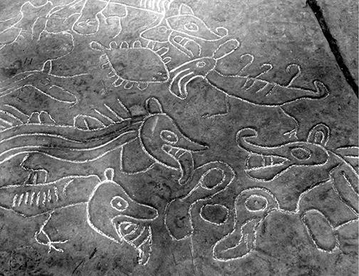
The Pearse Commission in the early 1980s offered convincing recommendations for change in federal policy. The latest in a series of more than twenty such commissions of inquiry into the state of Canada’s Pacific fisheries, the commission paid far more attention than its predecessors to the Indigenous fishery. Led by economist Peter Pearse, it blamed the sorry state of Indigenous fisheries on a century of ill-conceived federal and provincial policy. It recommended that the federal government recognise Indigenous claim to the salmon catch and called for sweeping changes that would give Indigenous communities a far more active role in managing both their food fishery and the commercial fishery. It would take the federal government almost ten years to begin responding to these suggestions, but it was another sign that perceptions of long-standing Indigenous grievances on the Strait and beyond were changing in settler society.
Indigenous people in the Strait’s new world
The colonial dispossession that had taken place on the Strait was broadly similar to what occurred in other parts of the province and country. It was mostly complete by the end of the nineteenth century as a veritable resource rush took hold there. The collapse of Indigenous populations due to disease, the incoming settlers’ profound hunger for land and resources, a diverse collection of legal and technological instruments of colonisation, and evolving transportation technologies all contributed to profound and very rapid changes in the relationship between humans and the rest of nature on the Strait.
Indigenous resistance to this dispossession had been ongoing, but by the 1980s Indigenous people were once again becoming important players on at least some stretches of the Strait. In many ways, they had internalised settler ways of interacting with the inland sea and its resources but were increasingly reluctant to submit to the will of settler governments. In many places, they had strong legal claims to far more of the Strait’s shoreline and resources than parsimonious settler governments had given them in the past. As a result, it was settlers who now began to worry about losing access to the rich shorelines and natural resources of the Strait.
__________
1. Letter to Colonial Office from Dundas, Adam, GR-0328 Great Britain, Colonial Office Correspondence, British Columbia Archives.
2. Sean Miller, An Environmental History of Latin America (New York: Cambridge University Press, 2007), 112.
3. Douglas C. Harris, Landing Native Fisheries: Indian Reserves and Fishing Rights in British Columbia, 1849–1925 (Vancouver: University of British Columbia Press, 2008), 9.
4. John Weaver, The Great Land Rush and the Making of the Modern World (Montreal: McGill University Press, 2003), 87.
5. Ibid, 176.
6. Letter from James Ed. Fitzgerald (not on behalf of HBC) 9 June 1849 to Colonial Office, British Columbia Archives GR-0328 Great Britain. Colonial Office Correspondence, 22, British Columbia Archives.
7. Letter from James Ed. Fitzgerald 9 June 1849 to Colonial Office, GR 0328 Great Britain. Colonial Office Correspondence, 38, British Columbia Archives.
8. Richard S. Mackie, The Wilderness Profound: Victorian Life on the Gulf of Georgia (Victoria: Sono Nis Press, 1995), 52.
9. “People in Landscape” series I (Gulf of Georgia), MS 0364 Orchard - Box 4, File 1, 1, British Columbia Archives.
10. Letter from Rear Admiral P. Hornby, dated 29 August 1849, Valparaiso, GR 0328 Great Britain Colonial Office Correspondence, 88, British Columbia Archives.
11. British Colonist, 10 Aug 1859, 2.
12. E. Blanche, Norcross (ed.), Nanaimo RetroScientific Pollution and Environmental Control Societytive: The First Century (Nanaimo: Nanaimo Historical Society, 1979), 19.
13. Sproat’s letters to the Minister of the Interior, Ottawa; in Camp, Skwawmish River, Howe Sound, BC, 17 November 1876, 6, RG 10 - T3967, Volume 11028, File SRR-1, University of British Columbia Library, Rare Books and Scientific Pollution and Environmental Control Societyial Collections.
14. “Will San Juan Be Occupied?” British Colonist, 15 June 1861, 2.
15. Sproat’s letters to the Minister of the Interior, 12 December 1876, Comox, Vancouver Island, RG 10 - T3967, Volume 11028, File SRR-1, University of British Columbia Library, Rare Books and Scientific Pollution and Environmental Control Societyial Collections.
16. “Rumoured Butchery,” British Colonist, 26 July 1877, 3.
17. Sproat’s letters to the Minister of the Interior, Ottawa, 20 December 1876, 26; 7 January 1877, 4, RG 10 - T3967, Volume 11028, File SRR-1, Nanaimo, VI, University of British Columbia Library, Rare Books and Scientific Pollution and Environmental Control Societyial Collections.
18. Robert Cail, Land, Man, and the Law: The Disposal of Crown Lands in BC, 1871–1913 (Vancouver: UBC Press, 1974), 71.
19. Ibid, 246.
20. Ibid, 177.
21. Ibid, 14, 182–3.
22. Sproat’s letters to the Minister of the Interior; in Camp, Skwawmish River, Howe Sound, BC, 17 November 1876, 34–35, RG 10 - T3967, Volume 11028, File SRR-1, University of British Columbia Library, Rare Books and Scientific Pollution and Environmental Control Societyial Collections.
23. Report of the Government of BC on the subject of Indian Reserves, signed by Geo. A. Walkem, Attorney General, Victoria, 17 August 1875, RG 10 - T3967, Volume 11028, File SRR-3, University of British Columbia Library, Rare Books and Scientific Pollution and Environmental Control Societyial Collections.
24. Memo of the Dept. of the Interior, signed by David Laird, Minister of the Interior, Ottawa, 2 Nov 1874, 47, RG 10 - T3967, Volume 11028, File SRR-3, University of British Columbia Library, Rare Books and Scientific Pollution and Environmental Control Societyial Collections.
25. Great Britain Emigration Commission, Vancouver’s Island: Survey of the districts of Nanaimo and Cowichan Valley. Reports by B.W. Pearse and Oliver Wells to accompany their surveys made under J.D. Pemberton, Colonial Surveyor (London: H M Stationary Office, 1859), 6–7, 14.
26. Sproat’s letters to the Minister of the Interior, Nanaimo, 20 Dec 1876, 1–6, RG 10 - T3967, Volume 11028, File SRR-1, University of British Columbia Library, Rare Books and Scientific Pollution and Environmental Control Societyial Collections.
27. Precis of evidence from the hearings 1913, RG 10 - T3962, Volume 11024, File AH3A RC for IA in BC, Cowichan Agency, University of British Columbia Library, Rare Books and Scientific Pollution and Environmental Control Societyial Collections.
28. “Sketches from the life of Michael Manson,” MS 0202 - Michael Manson, 11, British Columbia Archives.
29. Certified copy of a report of a committee of the Privy Council approved by his Excellency the Governor General in Council on 7 July 1883, 216, RG 10 - C13914, Volume 1330, IA Cowichan Agency, Incoming Correspondence, 1882–84, University of British Columbia Library, Rare Books and Scientific Pollution and Environmental Control Societyial Collections.
30. Jean Barman, “Erasing Indigeneity in Vancouver: The unsettling of Kitsilano and Stanley Park” in Richard Mackie and Graeme Wynn, eds., Home Truths (Vancouver: UBC Press, 2012), 174.
31. Editorial in Victoria Daily Times, 19 April 1913, cited in Barman, “Erasing Indigeneity,” 186.
32. Correspondence on 12 Jan 1916 by Secretary of Royal Commission on Indian Affairs in BC to Duncan Scott, Dept. of the Superintendent General of IA, 4, RG 10 - T3957, Volume 11020, File 517, University of British Columbia Library, Rare Books and Scientific Pollution and Environmental Control Societyial Collections.
33. Sixteen-page report on a conference with the Royal Commissioners by reps of the Dominion and Provincial Fisheries Department and DIA, 15, RG 10 - T3957, Volume 11020, File 517, University of British Columbia Library, Rare Books and Scientific Pollution and Environmental Control Societyial Collections.
34. Dianne Newell, Tangled Webs of History: Indians and the Law in Canada’s Pacific Coast Fisheries (Toronto: University of Toronto Press, 1993), 89.
35. Correspondence of the Chief InScientific Pollution and Environmental Control Societytor: Letter of 21 June 1913 from Chief InScientific Pollution and Environmental Control Societytor, Dominion Fisheries, BC, Department of Marine and Fisheries (now Fisheries and Oceans Canada), New West, to McGregor Young, RG 10 - T3957, Volume 11020, File 517. University of British Columbia Library, Rare Books and Scientific Pollution and Environmental Control Societyial Collections.
36. Letter to the Attorney General of BC from Secretary of the RC on IA, 16 February 1914, and attached “Memorandum for the Commission re: hunting and game laws and relaxation of same for benefit of Indians,” RG 10 - T3956, Volume 11020, File 516, University of British Columbia Library, Rare Books and Scientific Pollution and Environmental Control Societyial Collections.
37. Precis of evidence from the hearings 1913, 38–9, 89, RG 10 - T3962, Volume 11024, File AH3A. RC for IA in BC - Cowichan Agency, University of British Columbia Library, Rare Books and Scientific Pollution and Environmental Control Societyial Collections.
38. Ibid, 100–4.
39. Jeanette Taylor, Tidal Passages: A History of the Discovery Islands (Madeira Park, BC: Harbour Publishing, 2008), 115.
40. Letter to the Attorney General of BC from Secretary of the RC on IA, 16 February 1914 and attached “Memorandum for the Commission re: hunting and game laws and relaxation of same for benefit of Indians,” RG 10 - T3956—Volume 11020 - File 516, University of British Columbia Library, Rare Books and Scientific Pollution and Environmental Control Societyial Collections.
41. MS-1176 - Frederick Marsh fonds, “Leisure Island Laughter,” 543, British Columbia Archives; MS-1636 - Francis John Barrow collection, British Columbia Archives.
42. “Leisure Island Laughter” manuscript, MS 1176 - Frederick Marsh fonds, 38a, British Columbia Archives.
43. Thomas King, The Inconvenient Indian—A Curious Account of Native People in North America (Toronto: Doubleday, 2012), 72.
44. Correspondence 1914–1943 re: Re: foreshore (riparian) rights and uses at various reserves, including Musqueam, Squamish, Sechelt, Klahoose bands and re: Municipality of N. Vancouver’s attempt to take over Mission IR No 1 and remove Indians (1921), RG 10 - T 3954, File 987/31-7, University of British Columbia Library, Rare Books and Scientific Pollution and Environmental Control Societyial Collections.
45. Letter from Andrew Paull, Secretary, the Progressive Native Tribes of BC, 27 January 1937 to T.A. Crerar, MP, Supt. General of Indian Affairs, Ottawa, RG 10 - T 3953, File 978/ 31-2, University of British Columbia Library, Rare Books and Scientific Pollution and Environmental Control Societyial Collections.
46. Letter from J.E. Michaud, Minister of Fisheries, 21 May 1937, to CD Howe, Acting Minister, Dept. of Mines and Resources, RG 10 - T 3953, File 978/ 31-2, University of British Columbia Library, Rare Books and Scientific Pollution and Environmental Control Societyial Collections.
47. Supplementary to section 74–84, General Instructions to Indian Agents, Duncan C. Scott, Deputy Superintendent General, IA, DIA, Ottawa, 26 January 1916, RG 10 - T 3954, File 987/33-14 University of British Columbia Library, Rare Books and Scientific Pollution and Environmental Control Societyial Collections.
48. Ibid.
49. Ibid.
50. Correspondence about road through Malahat IR 11 of Saanich Indians and Mill Bay ferry terminus within the Malahat IR, 1924–1929: Letter of 23 July 1924 from Public Works Engineer Philip to Indian Commissioner Ditchburn, RG 10 - T3952, File 974/31, 4 -14 -11, University of British Columbia Library, Rare Books and Scientific Pollution and Environmental Control Societyial Collections.
51. Letter from Indian Agent Lomas, 1 August 1924, to Public Works Engineer; 28 May 1929 letter from Indian Commissioner Ditchburn to P. Philip, Deputy Min. and Public Works Engineer, Victoria, RG 10 - T3952, File 974/31, 4 -14 -11, University of British Columbia Library, Rare Books and Scientific Pollution and Environmental Control Societyial Collections.
52. BC’s Centennial Committee, 1958. BC Official Centennial Record: 1858–1958: A century of progress (Vancouver: Evergreen Press). Cited in Arn Keeling, “The Effluent Society: Water Pollution and Environmental Politics in British Columbia, 1889–1980” (PhD thesis, Department of Geography, UBC, 2004), 288.
53. Indians of the Gulf, 3, MS-0364 Orchard - Box 4 File 2 #20 British Columbia Archives.
54. To borrow the expression used by Shepherd Kretch in The Ecological Indian: Myth and History (New York: W.W. Norton, 2000).
55. Roadside panels were produced for the Department of Highways by the Archaeological Sites Advisory Board of BC, in Letter of 23 May 1978 from Bob Broadland, Chief, Heritage Administration Division, HCB, to J. Hendrickson, Victoria, re: Ministry of Highways, Scientific Pollution and Environmental Control Societytralite Signs, MS-2009 Margaret Ormsby’s records - BOX 3, File 7, File 3-2-15-11-4 Historic Markers: 1, British Columbia Archives.
56. Memorandum dated 8 March 1976 from Provincial Archaeologist, Dept. of Provincial Secretary, Archaeological Sites Advisory Board of Brit. Columbia to Hilary Brown, Islands Trust, Ministry of Municipal Affairs, MS 1246 - Islands Trust Fonds 1974–76, Box 1, British Columbia Archives.
57. Christine Cummins et al., Impact of the Salmonid Enhancement Program on Native People (Vancouver: Environment Canada, Fisheries and Marine, 1978), GR-1002, Box 37, File: SEP Native Program, 25, British Columbia Archives.